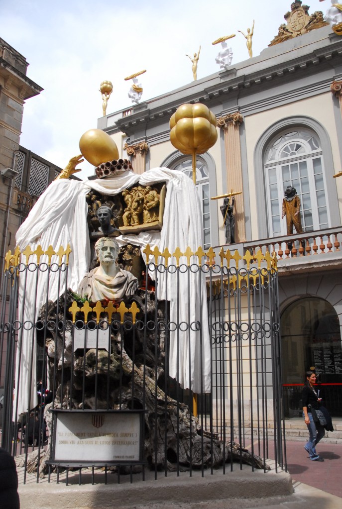
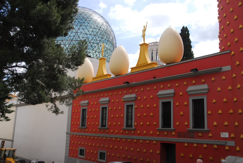
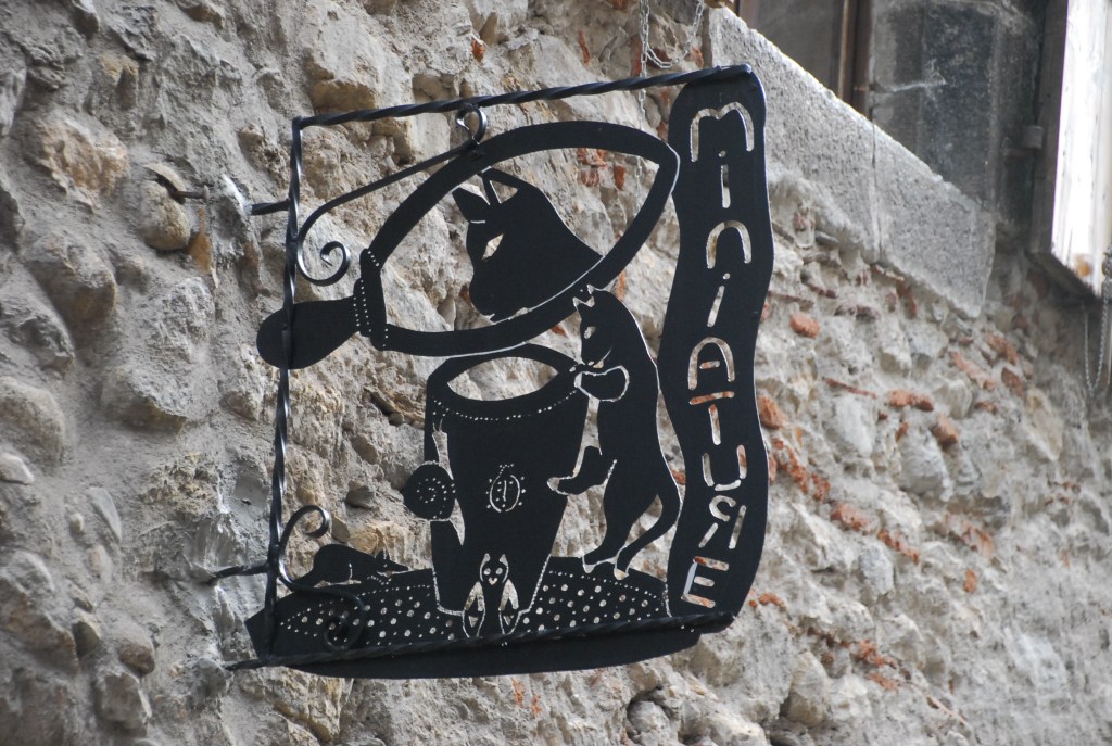
It was crowded and seemingly disorganized, such a contrast to my previous visit to the famous Dali museum at Figueres, that almost; no, definitely, indescribable edifice that reminds you of no other; like the man himself, it is unique.
The short road to the carpark was being dug up and we had to wait about 15 minutes just to get into the carpark, relying entirely on those leaving the museum to vacate their spot. Bizarrely, as if in keeping with Dali’s theme of thinking outside the square, you are charged 0.043229 euro cents per minute for your stay in the carpark; and this is just the first thing designed to fleece the tourists.
The museum itself (when you finally get in after waiting with the busloads) is a masterpiece of involvement with art, i.e., every piece makes you think. His extraordinary gifts spanned so many of the arts it is hard to believe that only one man conceived all this. From his exquisite jewellery pieces to his art that was on another planet, the museum never fails to grab your attention.
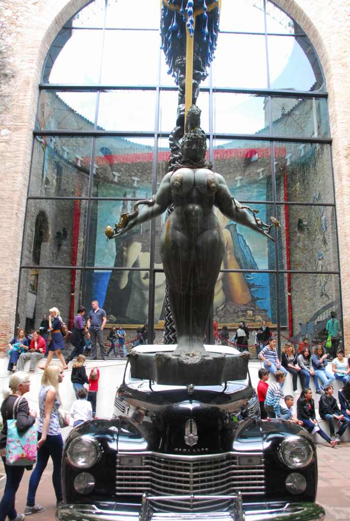
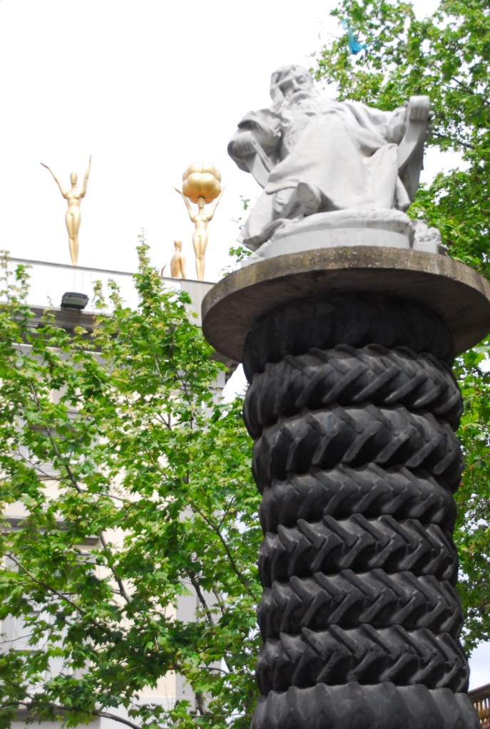
The famous centrepiece of the Cadillac with vines on the dash and a spray system that will keep the snails inside alive is activated if you insert 20 cents into a slot , the bronze fat lady with snakes on her arms on the bonnet, the stack of tyres topped by a statue of a man wrapped in a tyre himself that has a bust secreted in another tyre at his feet and all of this beneath a boat with huge droplets of water clinging to its side and a mast topped by an umbrella and who knows what else we missed is mind boggling to say the least.
It’s set in what used to be an opera theatre that was accidentally burnt down during the Spanish Civil War and Dali’s idea was that you go in here not to see art but to have a theatrical experience. I believe he got that right.
A GERIT DOU WORK. FINE ART AT ITS BEST
He was a fan of many artists including one of my favourites, Gerit Dou, who has two works featured either side of an El Greco portrait titled Saint Paul and all are on show in his Masterpieces Gallery along with one of Dali’s most admired painters Meissonier.
Jean-Louis Ernest Meissonier
Much of the rest is mayhem and, as Dali intended, you can never see it all in one visit, or two or three for that matter, because so much will elude you, leaving it fresh for discovery on your next incursion.
DEPENDING ON WHERE YOU VIEW THIS FROM, IT’S EITHER ABRAHAM LINCOLN OR A NUDE
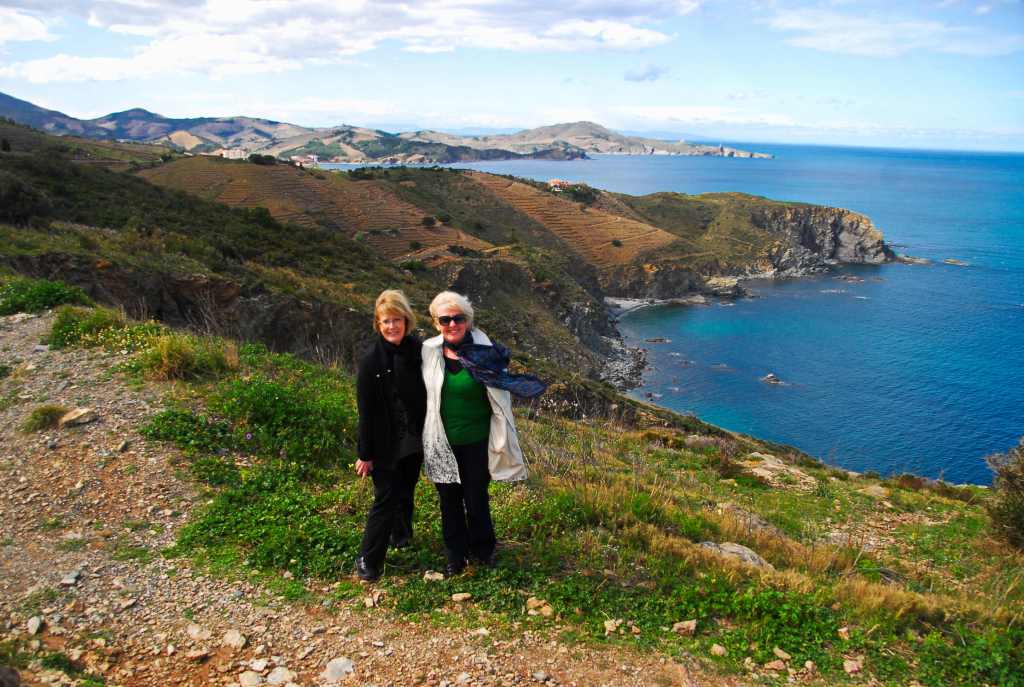
Our day then took us south to the Mediterranean, thrust on by yet another storm, buffeted by the Tramontana that falls off the Pyrenees which accompanied us nearly all the way to the sea where it almost mysteriously disappeared for the remainder of the day so we could enjoy the beauty of the Vermilion Coast, taking time for a repast at the bustling Banyuls-sur-Mer followed by dinner at the delightful Collioure.
BRAVING THE TRAMONTANA
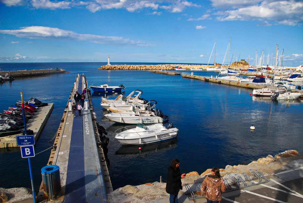
Banyuls-sur-Mer is brash, with modern sculpture, modern boats, jet skis, lots of three storey accommodation houses, busy shopping in tree lined streets and a Catalan flag or two. There’s a bustling holiday atmosphere about the place, unlike Collioure, that’s steeped in history.
BUSY PORT OF BANYULS SUR MER
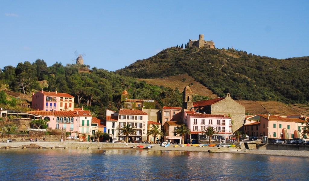
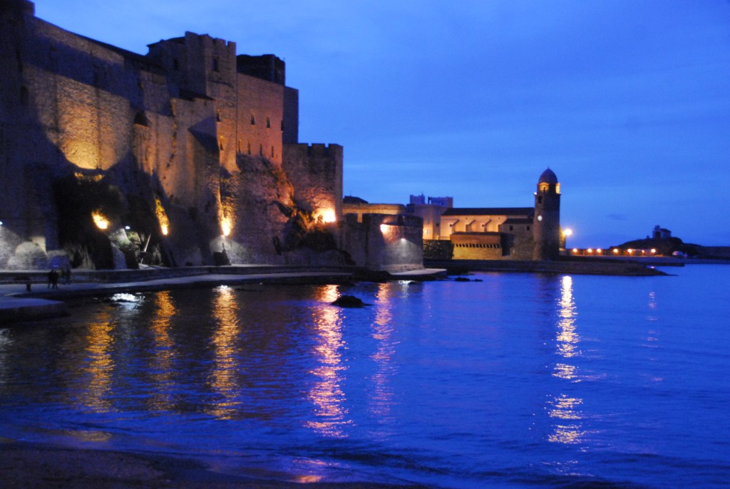
Overlooked from on high by the 16th C Fort St. Elme of Charles V, then a windmill on the next level down and finally overseen by the waterside castle, originally a Roman castrum, Collioure’s splash of pastel shops are at odds with the drab buildings blocks of the fortifications.
FORT ABOVE THE WINDMILL AND THE BAY
The castle was occupied by Visigoth king Wamba in 673, but has had many noticeable additions since then and was used as the summer palace of the Kings of Majorca in the 12th century.
CASTLE DIRECTLY OVER THE HARBOUR
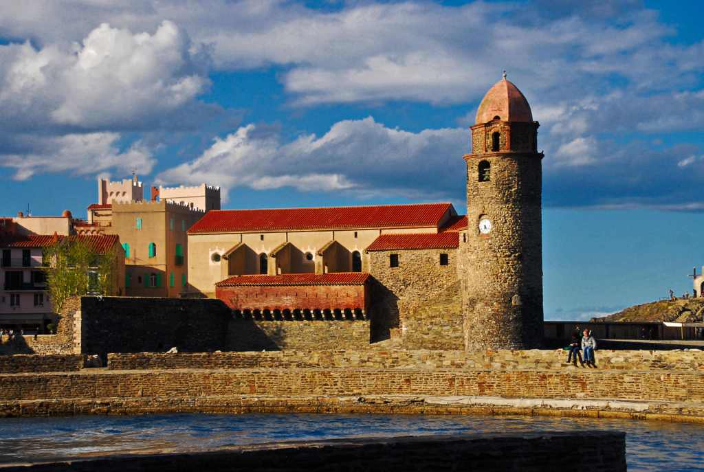
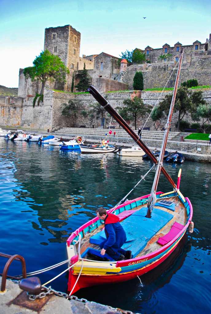
Along the sea front is the lovely church bell tower (that once doubled as a lighthouse) of the Notre Dame des Anges, the symbol of Collioure, which is reflected in the waters of the harbour on whom the sun shines for 300 days of the year. The pastel dome was only added in 1810.
It overlooks the small harbour with its traditional colourful fishing boats, their mast sticking up from the centre of the open craft.
It’s been an inspiration for artists; Picasso, Matisse, Derain, Dufy, Chagall and Marquet to name but a few, and is touted as the birthplace of Fauvism though we’re too late to visit the galleries.
NICE VIEW FOR DINNER
I’d planned to stop and eat here and that’s exactly what happened. What better way to finish a day than relaxing by the bay of Ansa de Baleta with its gentle waters lapping on the coarse sand as the sun retreated and the evening lights came on to dance across the water. Bon appétit!
Le Petite Jaune (the little yellow) is a tourist train that I’d like to say huffs and puffs its way into the Pyrenees, except it’s electric, from a place called Villefranche de Conflent, itself a special place with fortifications started back in the 11th century and enlarged over the years. However, it was vulnerable so Fort Liberia was erected high (734 steps up) on the side of the steep canyon in 1679 to overlook the situation when Vauban was in charge. Just in case you were unaware, Sébastien Le Prestre, marquis de Vauban (1633-1707), was responsible for fortifications during the reign of King Louis XIV and was charged with reinforcing France’s defences. There are 130 strongholds, forts, guard houses, bastions and defensive structures bearing witness to Vauban’s productivity and dedication.
Villefranche reeks of authenticity and its narrow streets, once the province of tradesmen, today house craft and tourist shops with the odd restaurant.
We were there for the train ride though and the anticipation built during our half hour wait for the train that leaves at odd times about every hour. Once on board the three carriage affair we moved slowly out of Villefranche, deeper into the gorge cut by the river Tet, a rushing torrent that was never out of sight until near the end of our trip.
The catabatic wind whistled down the gap, bending branches here and there and introducing the chill from the snows on high. We photographers who braved the elements on the balcony outside may have gotten better photographs but had to pay a price.
All the way to Villefranche in the car and during the early stages of the train trip the supreme snow-capped peak of Le Canigou rose majestically skywards making it easy to understand why the locals hold it in such reverence. At every slight gap in the canyon walls, there it stood, clouds gathering as if to pay it homage while the spring thaw drained its mantle of snow to expose its lower slopes.
After well over an hour we reached the ski resort of St. Louis where the man behind the desk at our timeshare had advised us to alight. There’s nothing to eat there, no coffee, no alcohol, despite a steady stream of tourists. The train goes on further but he had said it was just “more of the same”.
The wind didn’t do us any favours except make the air clear during our 45 minute stay there; just enough time for a short walk and then back to the station where we attacked the snack and drink dispenser with gusto.
On the return journey two of us were nodding off, a reflection on the fact that we exhaust ourselves every day, wanting to extract every last morsel from the plate of our holiday, never getting back to the accommodation before 10.00 p.m. and often after 11.
We savoured Villefranche and the lovely quirky shops, 12th century bridge and ramparts before leaving for lunch by the sea, the first time we’d seen the Mediterranean this trip. The plethora of medium rise apartment blocks, the coarse sand and the lack of surf meant it was awaiting the summer holiday season when you would be lucky to find a plot of sand to put your towel on.
We dined at a restaurant that night at Canet Plage that was run by a guy from the tiny Caribbean island of St. Martins. He and his wife had split and she’d moved back to Perpignan but his son kept ringing him so he came to France and bought the cafe.
Bidens Pilosa, aka farmers’ friend. There are things in nature that people don’t like. Most of them have a reason for being. I mean, without flies, there would be no coffee, though, as a tea drinker, I couldn’t really care. There are others though, mosquitoes and leeches to name but two, to which I’m struggling to attach benefits to. Bidens pilosa falls into that same category.
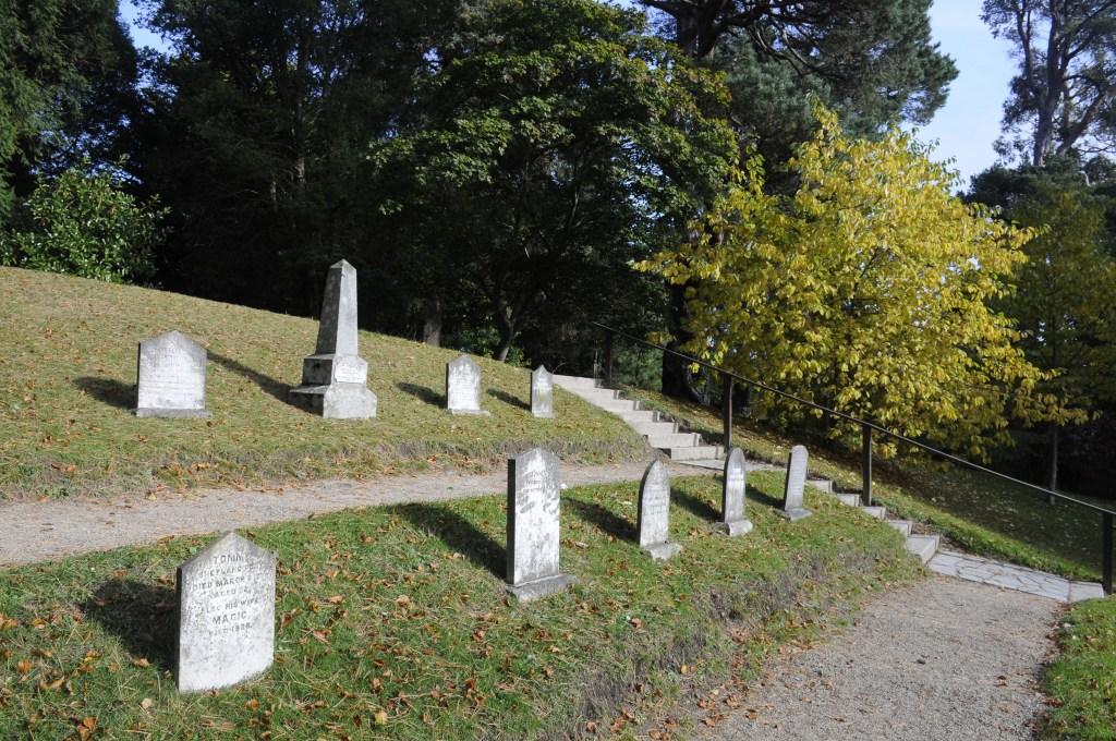
I’d been talking to Jim, one of Mike’s friends who’d stopped to chat while I was doing my one annual repair to the long suffering motorhome. Deep into the conversation I started into the granite outcrops around Moonbi. Jim wanted to know if I’d been out on Tanglewood Road, just past the cemetery. Well, actually, no. I’d never heard of Tanglewood or knew where the cemetery was.
Abandoning my bird shooting expedition, that I’d half planned, in a matter of seconds, I got full instructions with the intent of heading off immediately after a cuppa. Somehow, without asking, I just knew it was going to be on private property.
The road was smooth and I took the turnoff opposite the Caltex as advised and headed in the direction of Limbri. It hardly seemed anytime at all than I was noticing formations of interest, two in particular. Trouble was, there were houses in front of the formations. I went on, another house and fencing but then, just when I was resigned to door knocking, there was an unlocked gate beside a Telstra mast. The saying is “In like Flynn” and I took no prisoners so to speak.
One of the formations you can see from the road
While the heights seemed readily attainable, the weeds were in Easter party mode. They were in abundance after the recent rains and walking through them was going to be a nightmare. The rocks however, beckoned me on as I hid the Lambo and my backpack. I slipped through one fence and got to those granite pieces on the lower slopes. The cast-offs here were medium sized or smaller, obviously having broken off hundreds or thousands of years ago.
The main problem was you could only walk 2-5 steps before having to stop and find the best route, partly through the rocks, mainly through the weeds. I broke off over a thousand farmer’s friends, thereby severely denting the population by about .02 percent. You couldn’t totally avoid them or the ground hugging soft vine that had a penchant for wrapping itself around your ankles and shredding its tiny round seeds in the tongue of your boot while doing it.
While there was some interest in the shapes, I had high hopes for what was to come. I turned left, on reaching the saddle, towards one of the two outcrops I’d seen from the road, broaching fences regularly though, at times, they were hard to see, such was the proliferation of the weeds.
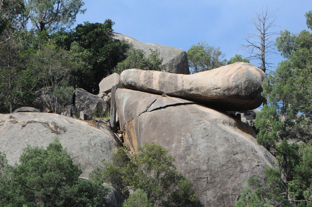
Then, as I started to climb, it started to get interesting, mostly due to the size I expect. Boulders were significantly larger, the cracks more dramatic, the oddities more strange. I also started to catch glimpses of the next high point I would eventually get to as well, so I had some bearings.
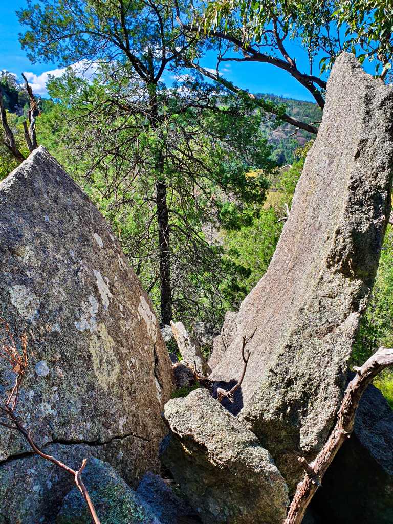
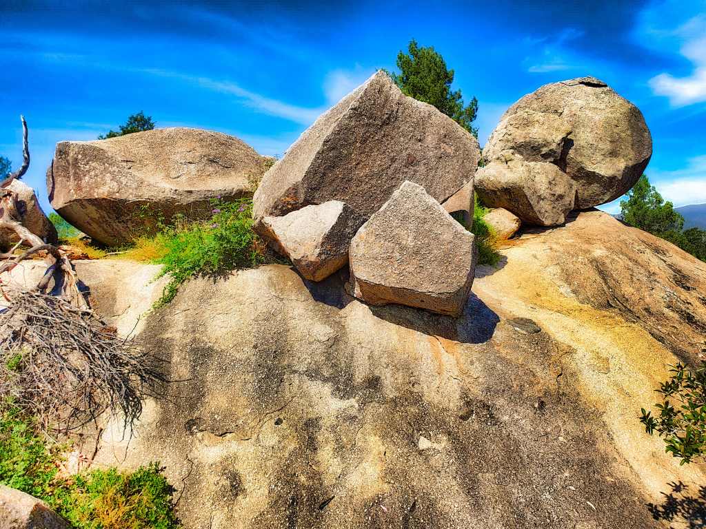
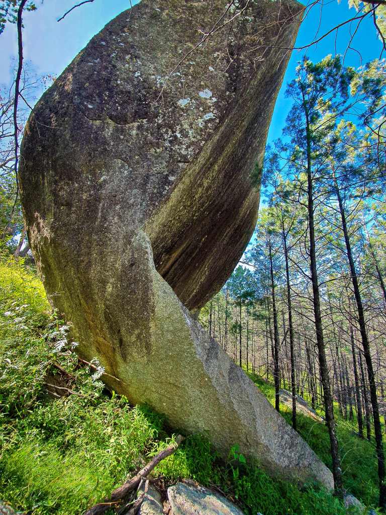
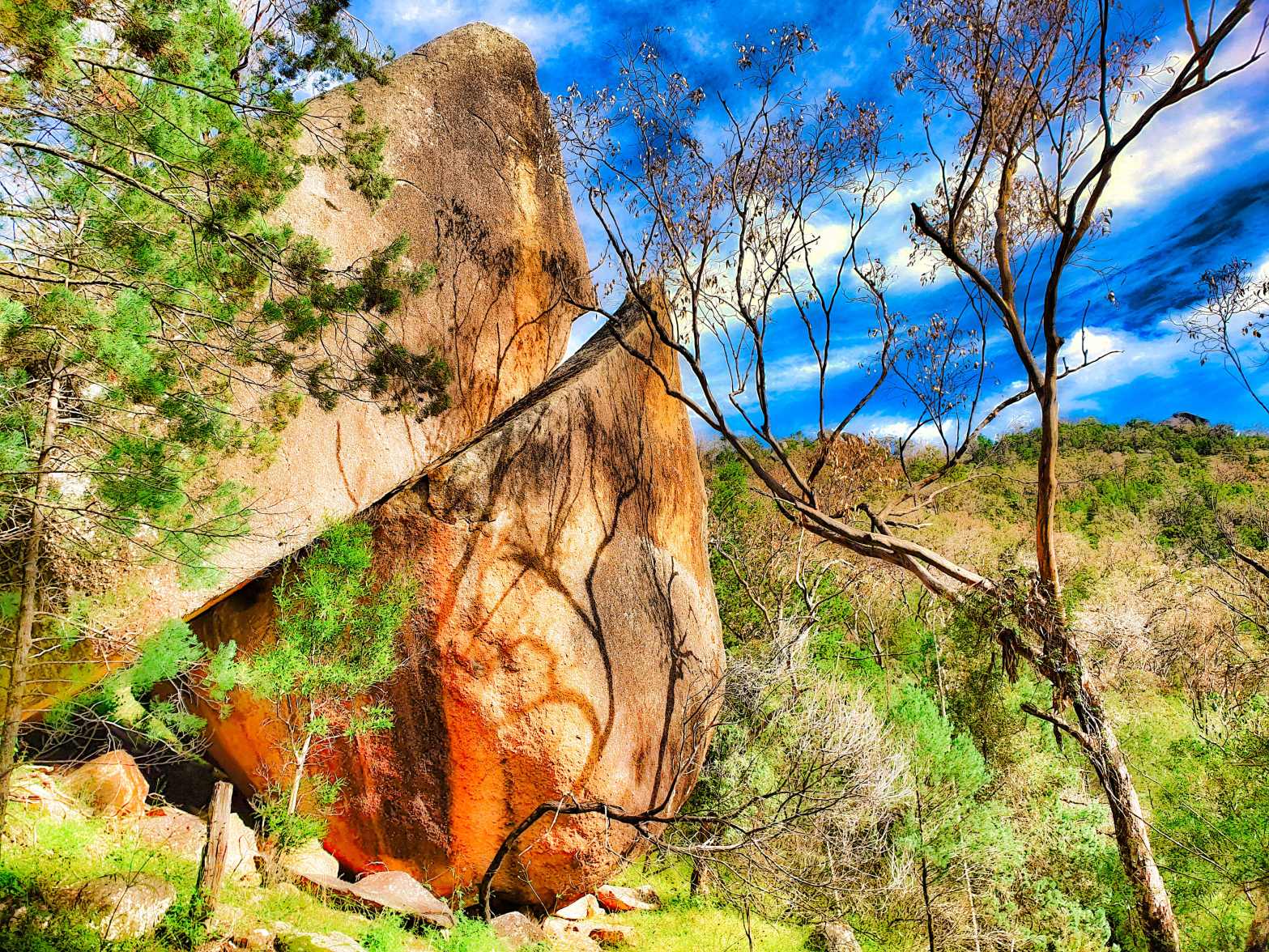
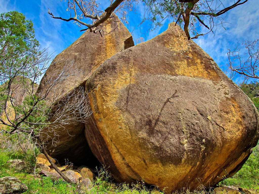
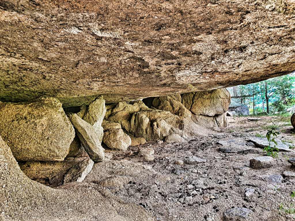
Rocks perched precariously on other rocks, a massive shard sticking up without its mother lode like a giant broken eggshell, a tall rock coming to a sort of point. I saw them all before I got to arguably the largest and walked around the side. To say I was dumbstruck would definitely be an understatement for there, right before me, was one of the strangest I’d ever seen.
About 35% of the largest I’d come across had disengaged, following two massive fault lines; one horizontal and one vertical. My head was shaking from side to side as I got closer, scrambled up some of the smaller fallen remnants and peered inside. It was extraordinary, both fault lines had parallel patterns of colour, probably an indication of what exactly had happened here. It was some time before I left it, still in wonderment.
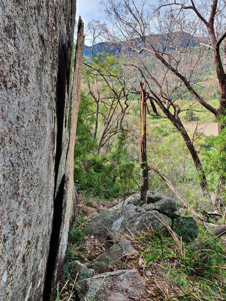
I turned back, got through another fence and headed across the next saddle. More bloody farmers’ friends. My boots were once again uncomfortably filling up with seeds. I crossed over another fence. There are no trails, just relentless knee to waist high weeds. My curiosity was my sole driving factor.
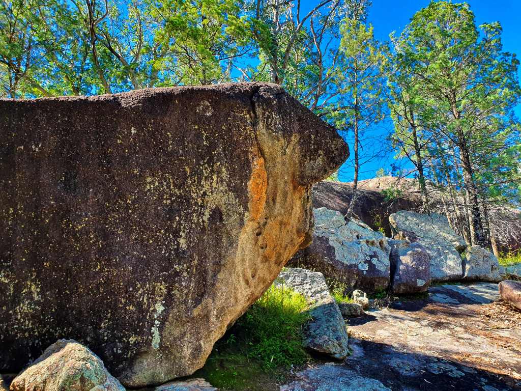
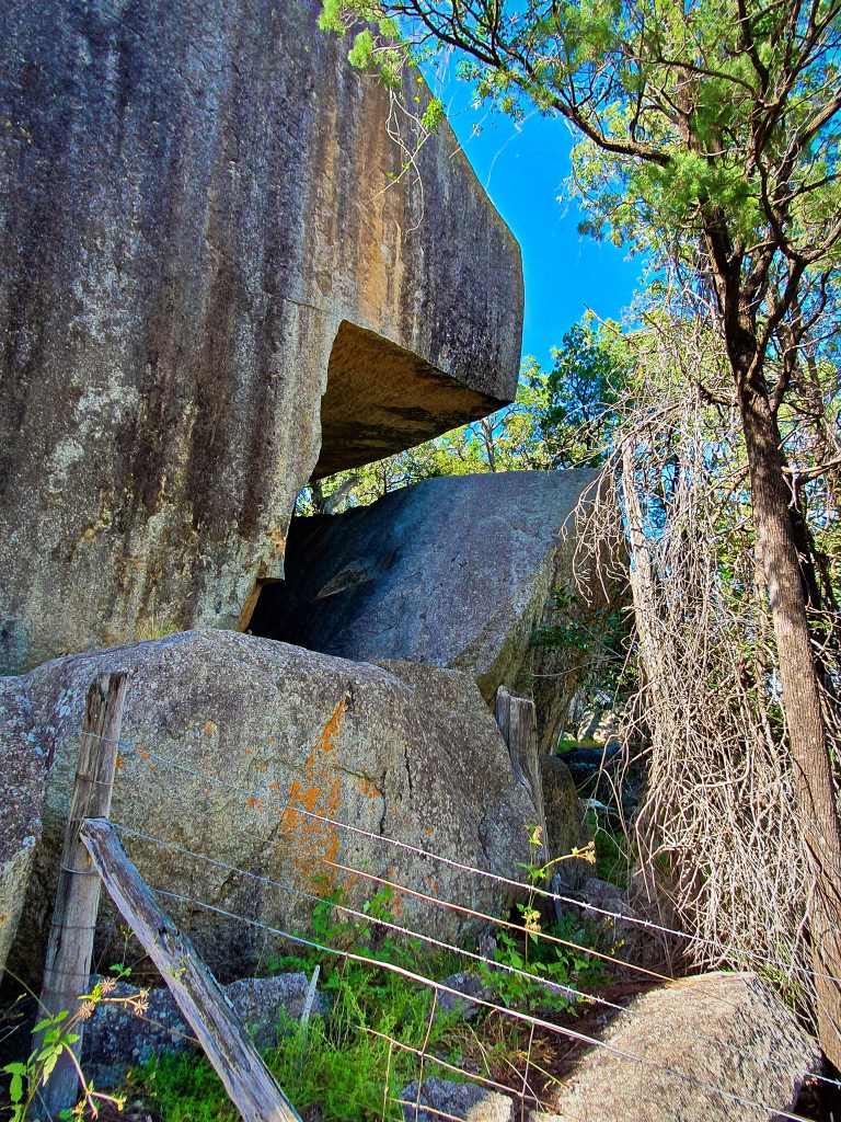
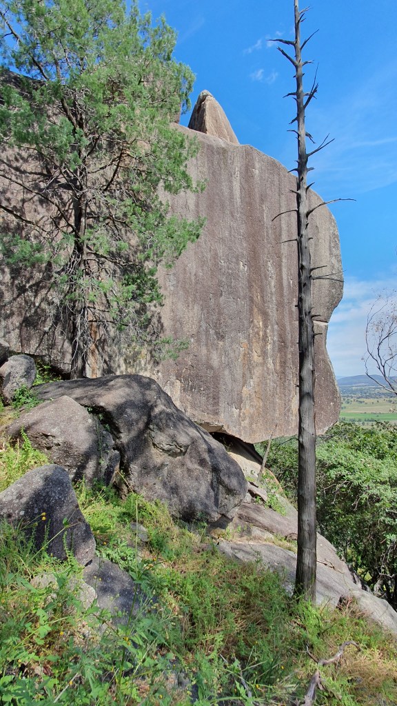
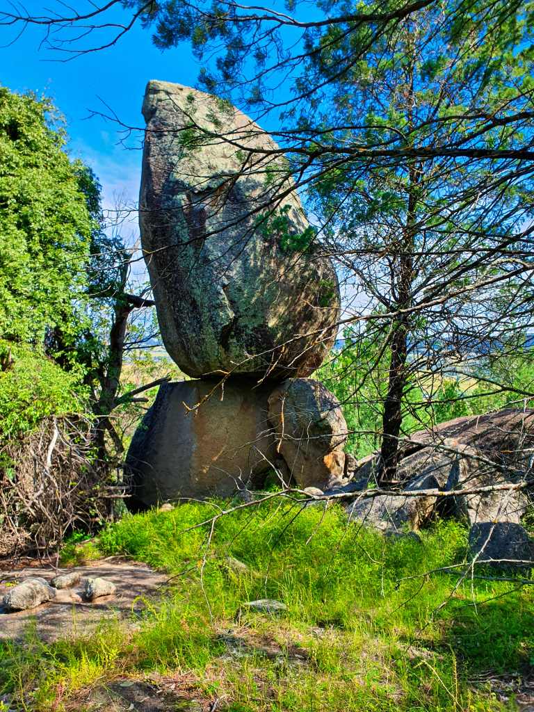
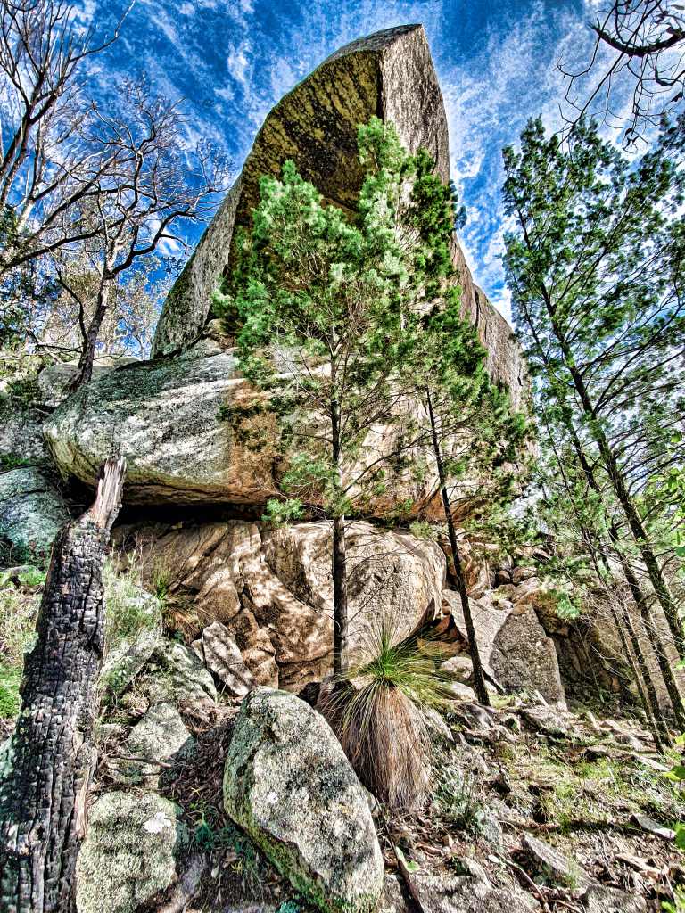
The ascent was steeper than the previous one and there were no shapes in the saddle; nothing until half way up the climb. I approached a squarish one with a large semi-hemisphere on top and, beyond it, a tall tower of a rock overshadowed them both.
Near the top the weeds flattened out and when I neared the largest outcrop it was sad to see that someone had painted their initials on it. I scouted around to the front that overlooked the valley beyond, squirmed along a slanting crack and made it almost to the top where all manner of granite destruction was taking place, judging by the odd shapes. Weather, the ubiquitous fig trees; heavens, there was even what I took to be rabbit dung in clutches on top of several of them.
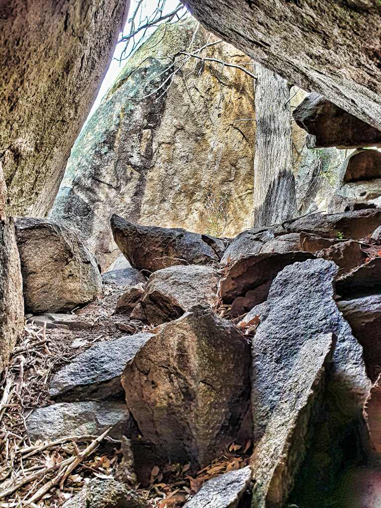
I sat down and did my shoes again. It seems to take ages to do a good cleanse, trying to remove every last irritant but always missing one or two. Still, the vast panorama made it a good place to stop.
Something to look at while you’re cleaning your shoes
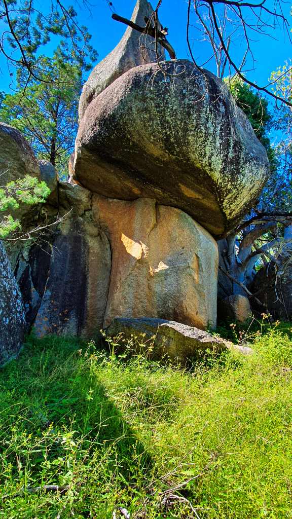
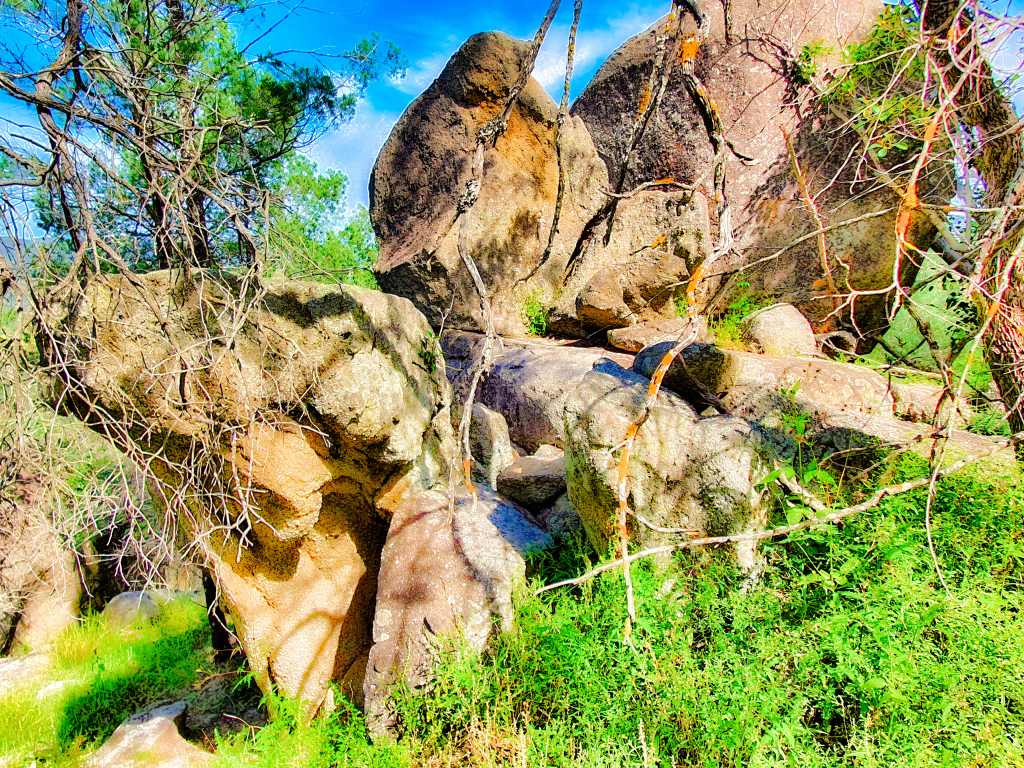
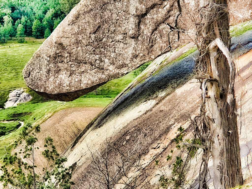
Then I cut across the front of the formations and reached another huge one, seemingly almost ready to slide down the hill judging by its undercut. I couldn’t get underneath it, the down slope being beyond my capabilities so I climbed again and then turned right for home, slowly working my way back across the second saddle. I’d already seen the stuff at the top of that mount so there were no expectations.
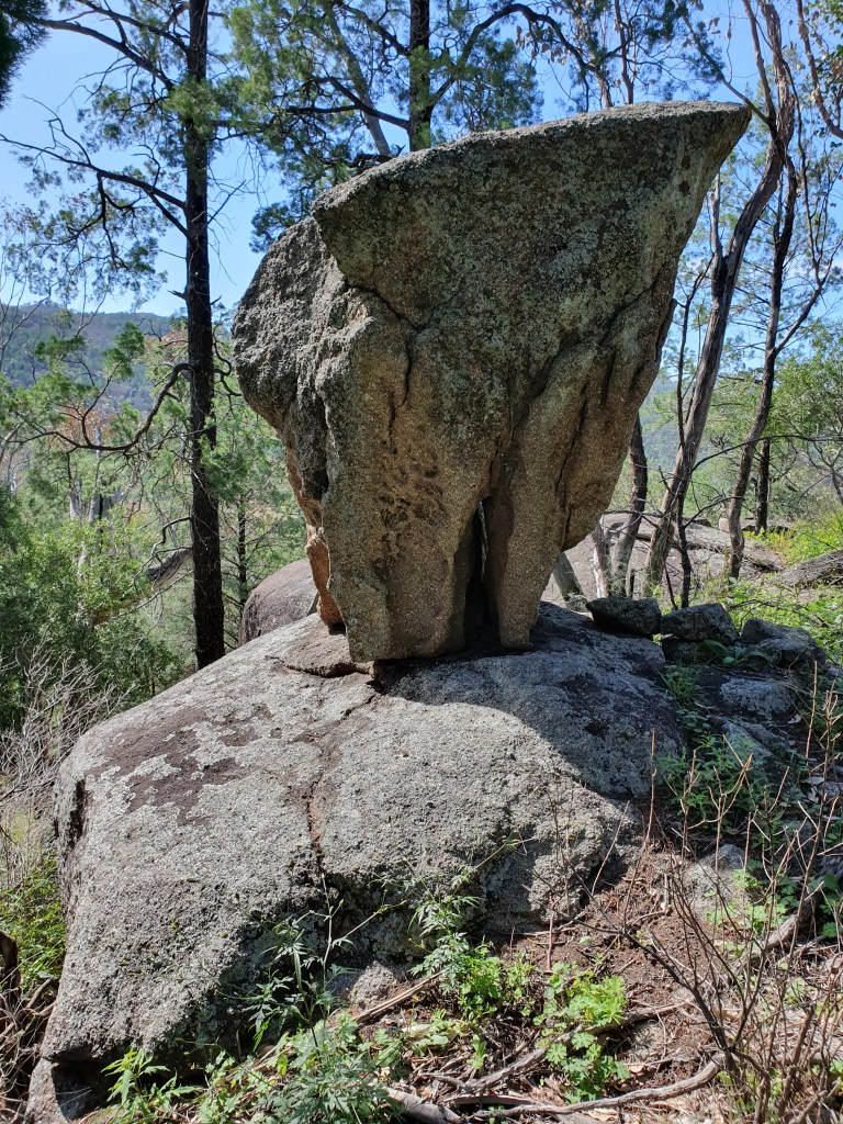
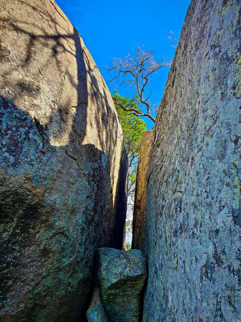
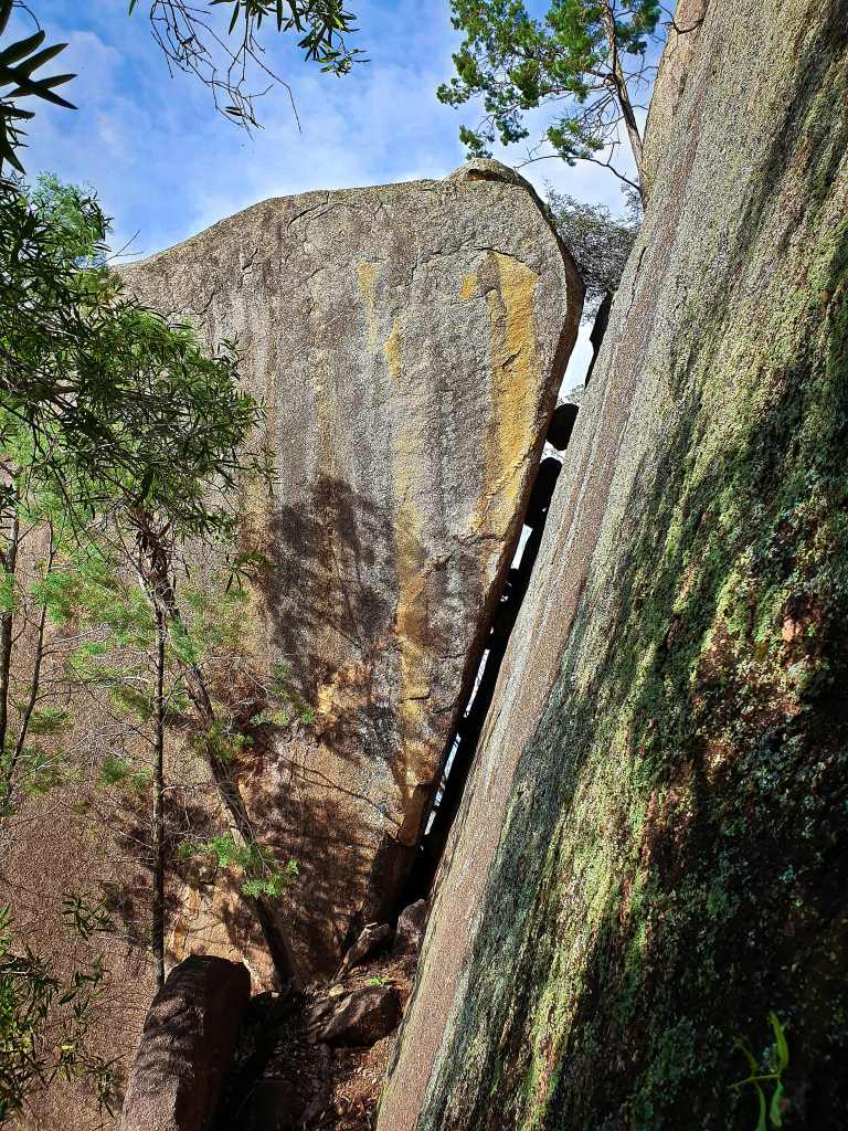
You know what, the thing that I’ve learnt here is that you only have to move a couple of metres in a different direction and you might be blown away. Well, I found a massive crack and worked my through to the other side. Not a lot to see on the other side; some interesting shapes, a wavy tree bark just before I passed another big rock.
Nothing prepared me for what evolved in the next ten metres for here was one of the most extraordinary formations ever. It looked for all the world like a giant mouth. Two large flat surfaces at around 140 degrees to each other. I knew while looking at it I’d never see its like again. It was hard to photograph because (a) you couldn’t get a decent angle at it and (b) I couldn’t stop gawking.
For the next hour while I slowly worked my way back I couldn’t get it out of my head. I’ve been to Girraween, done Boonoo Boonoo (pronounced bunny banoo in case you were wondering), climbed Bald Rock (several times) seen Draining Rock out of Tenterfield yet nothing was any better than what I’d seen here in the Moonbi area during two of the last three days.
My blister burst on my left ankle, my arm was bleeding from scratches and I stubbed my right big toe. The pain was excruciating, I doubted I could continue, but it eased after a minute or two. All travails were overcome by the persistent memory of what I’d recently seen. I was so happy when I reached the bike, full in the knowledge that the road home was all downhill but had to pause after I got through the gate for another exorcism of seeds. Only then did I notice that both soles on my expensive Scarpa hiking boots had all but come adrift after only half a dozen outings.
They have a potential tourist attraction here; it’s just that nobody realises it yet!
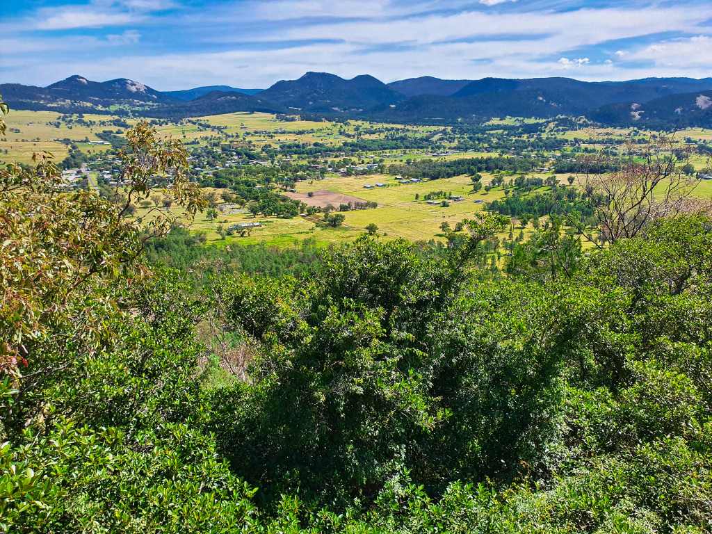
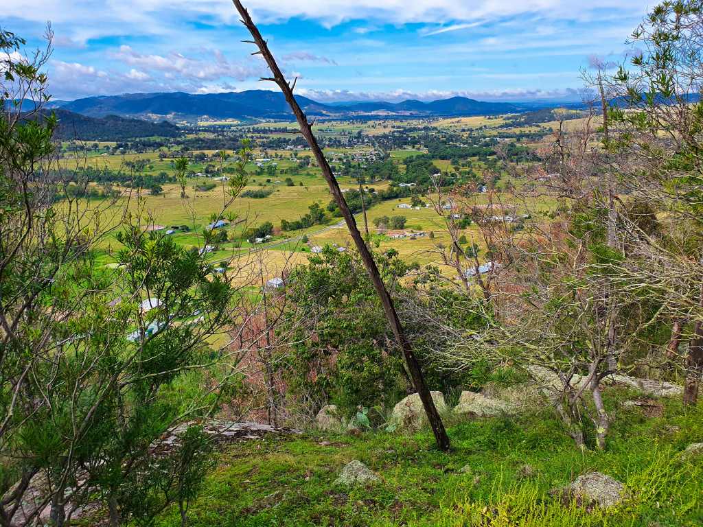
I was sure Mike had said it was a reserve. When confronted later he denied all. Perhaps it was my blind enthusiasm that affected my hearing two days before. Right now I was sitting on some lichen enriched granite and contemplating some of the best views of the New England area I’d ever seen while making a phone call.
It had been a difficult exercise getting this far, about two hours in. When I pulled up on my mountain bike and asked a stranger walking his dog where the entrance to the reserve was, he’d shaken his head, albeit with some reluctance, and then checked google maps. “No reserve shown anywhere here”, came the retort, this time with confidence. I was on my own from here on Gaol Creek Road, hoping there was no significance in the name.
I sighed, knowing, deep down, that I would soon be jumping (figuratively speaking of course) someone’s fence and heading in the general direction of “up” on private property. The granite was mesmerizing. There were two particular outcrops I desperately wanted to shoot after viewing from the road two days ago.
There’s a bike there, just before the rock
A 3 metre high rock near the fence line gave me some incentive for concealment. On my side was a thicket of “farmers’ friends”. About the only time I can think of the plant as being of some use to me. It stood around elbow height, ideal for hiding my bike and backpack. In fact, from 3 metres away you’d not even know it was there.
LOOKING FOR THE OUT-OF-SIGHT ROUTE
Soon I breached the barricade and followed an “out-of-sight-of-the-properties-on-either-side” route to reach where the main body of rocks and trees stood. It would be around three hours before I saw this spot again. With no trail, merely virgin scrub, it really felt like an adventure.
Granite outcrop after granite outcrop stood in my way. Other than the naked eye there was no indication as to which direction to take. I tended to the right, since there seemed less obstacles, and already I was viewing much more than my expectations had a right to.
Monoliths shattered in half over the aeons, threatening overhangs weighing hundreds of tonnes, rounded monsters lording over the tree line and, here and there, mysterious cracks between giants, some of which you could make your way through. There were also a few grass trees that had not fared well during the recent dry times.
Always there were plant seeds grasping at you making your way upward. They covered every lead taken and then, I came upon one of the curiosities I was to see today. There, on the side of a vertical slab, were anchor points for rock climbers. Had I not been considering a photo I would have passed them by unseen.
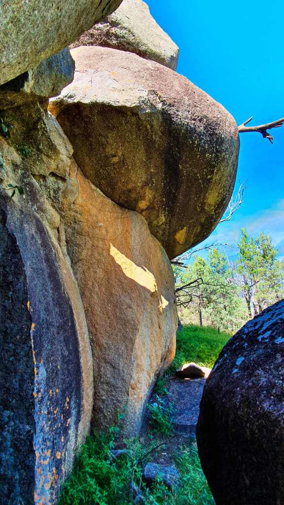
Next up was a pair of rocks that looked like the heads of Snugglepot and Cuddlepie, replete with pointy heads and a tree shadow for enhancement. Occasionally roots had penetrated the cracks, seeking the water from runoff no doubt. Another significant boulder had a large sliver coming off one side. Though that in itself is not unusual, the fact that mosquito – like insects were loving the inside of the crack I found fascinating.
THE SLAB WITH INSECTS BEHIND
Now I was veering slightly to the left, but also ever upward until I reached a point where I knew I was near the top. Rounding another great slab, the view indicated that I was, in fact, still a long way from the top. Bugger. Options were limited and zig-zags were common, luckily I had lots of things to hang onto though.
Now I was almost flying blind so to speak. Wherever one looked it seemed impossible until I chanced upon a rough tunnel scoured beneath one of the giants. Then I scrambled through and was on my way again, reaching near the top quite quickly while rubber-necking constantly. I made a conscious decision to aim for the left rock I fancied, since I’d taken a telephoto of the other one earlier from the road. It was around here I noticed a long ago discarded rusty horseshoe. How on earth had it got there?
THE WAY AHEAD THROUGH THE TUNNEL
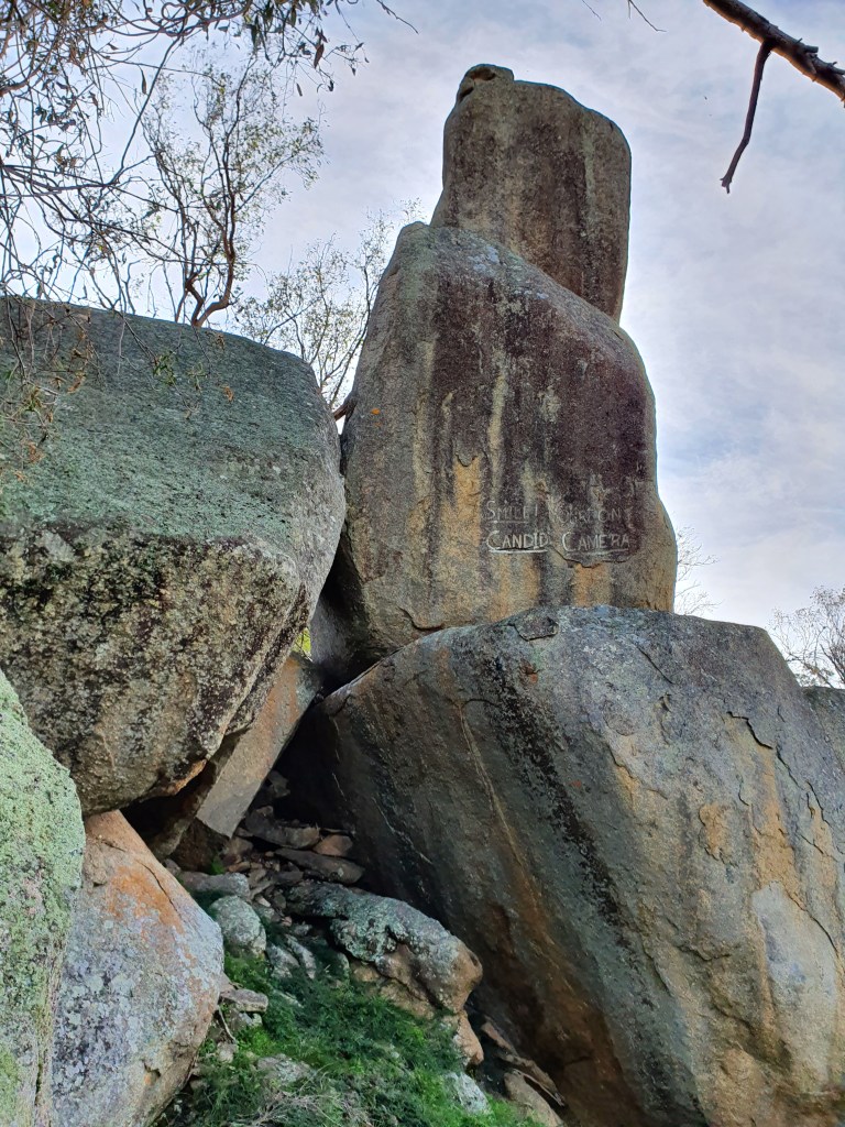
Weaving around I reached a significant vertical slab I’d seen from the road and stepped my way around to the other side, only to see some wit had written “Smile, you’re on candid camera”.
CANDID CAMERA INDEED
It coincided with a small track, the first I’d seen. After resting and making that phone call I followed the trail. It sure was a whole lot easier than what I’d been doing for the previous couple of hours and a quick descent got me to a vertically aligned fence line that a fallen tree had made a whole lot easier to negotiate, but then it was back into virgin scrub.
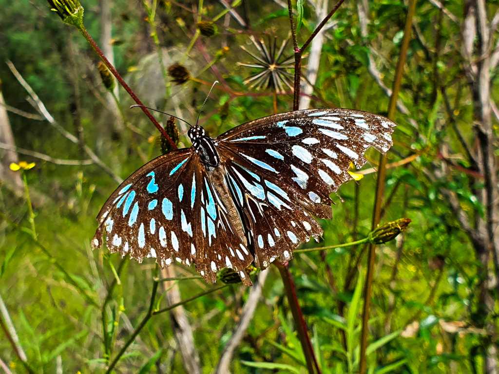
Butterflies were noticeable aiming for the lichen in one prolific spot as I scouted carefully coming down beside the biggest outcrop of all.
BLUE TIGER BUTTERFLY
The footing seemed like it might be a little uncertain in places, particularly where water had run down the granite and one slip could have meant a trip to the hospital……assuming someone could find you!
It was about half an hour before I stumbled over a spot that looked familiar. Relief was paramount because, if I was correct, the bike was only 15-20 minutes further down the hill, and so it turned out to be.
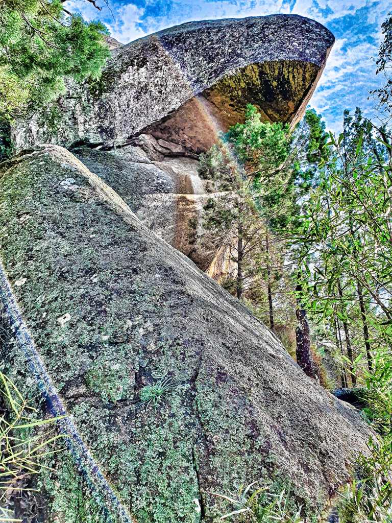
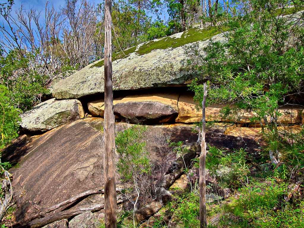
Right beside me though was another huge monolith, though it had been scoured from underneath and you can’t help but feel a little apprehensive as you slip into the cave like environment “Is today the day it moves and rolls on top of you?”
I found a much easier way over the two fences I’d slipped through at the start and soon I retrieved the Lambo and spent the next 10 minutes getting seeds and burrs off my clothing and shoes, much to the amusement no doubt of a couple of passing motorists.
Though I hadn’t made it to where I could photograph the two outcrops I’d aimed for, there was so much more I was amazed that the tor wasn’t a nature park of some sort. It was easily the best granite show I’d ever seen.
Oh, and the other thing I found up there; still can’t believe it – a golf ball!
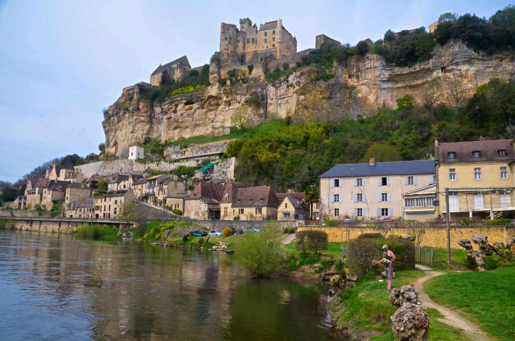
With Mademoiselle Baker’s seductive tones warbling midst the cackling of ravens as they built their nests in tiny alcoves in the nearby chapel, I knew it would be a repast to remember. Bathed in sunlight on the terrace brasserie at Chateau de Milandes we dined midst the budding Tilleuil trees contemplating our day’s itinerary.
So far we had seen Grotte de Font de Gaume, one of the prehistoric caves with paintings, attributed to the Magdalenians and at least 12,000 years old. This cave is the last in the whole area that is still open to the public. It has around 200 works and, though there weren’t many of them available for our viewing, they were a moving sight and the atmosphere was added to by an emotional and enthusiastic guide. It’s extraordinary to contemplate what it must have been like all those thousands of years ago with only a flame to aid their efforts. As Picasso was wont to remark upon seeing ancient paintings for the first time, “What have we learned?”
NO PICTURES ALLOWED INSIDE
We decided to leave the Milandes chateau and return for the bird show later; thus we found ourselves at Beynac, beneath the chateau perched atop an outcrop overlooking the Dordogne, as many other chateaux are. We walked along the riverbank and halfway up the hill, delighting in the photographic opportunities provided before we headed back to Mms. Baker’s residence.
BEYNAC
She had been a singer of international renown with an extraordinary career. Born in the States in 1906, she emigrated to France and became a citizen in 1937 when she married a Jew, but not before knowing the street life in America where she’d had to sleep in cardboard shelters and scavenge in garbage bins.
For ten years she was the lead in the Folies Bergeres, and admired by all who saw her. Shirley Bassey once said, “I swear in all my life I have never seen, and probably never shall see again, such a spectacular singer and performer.”
During WWII She won the Croix de Guerre for her work with the French Resistance. When the Germans invaded France she moved to the chateau where she helped Belgian refugees and ultimately adopted 12 children.
She was the first Afro-American to star in a major motion picture (Zouzou) and was the only female speaker in the civil rights march to Washington with Martin Luther King and was offered the lead in the movement when he was assassinated but she declined.
When the builders refurbishing the chateau sent her almost broke, Grace Kelly, a close friend, offered her accommodation on the Riviera.
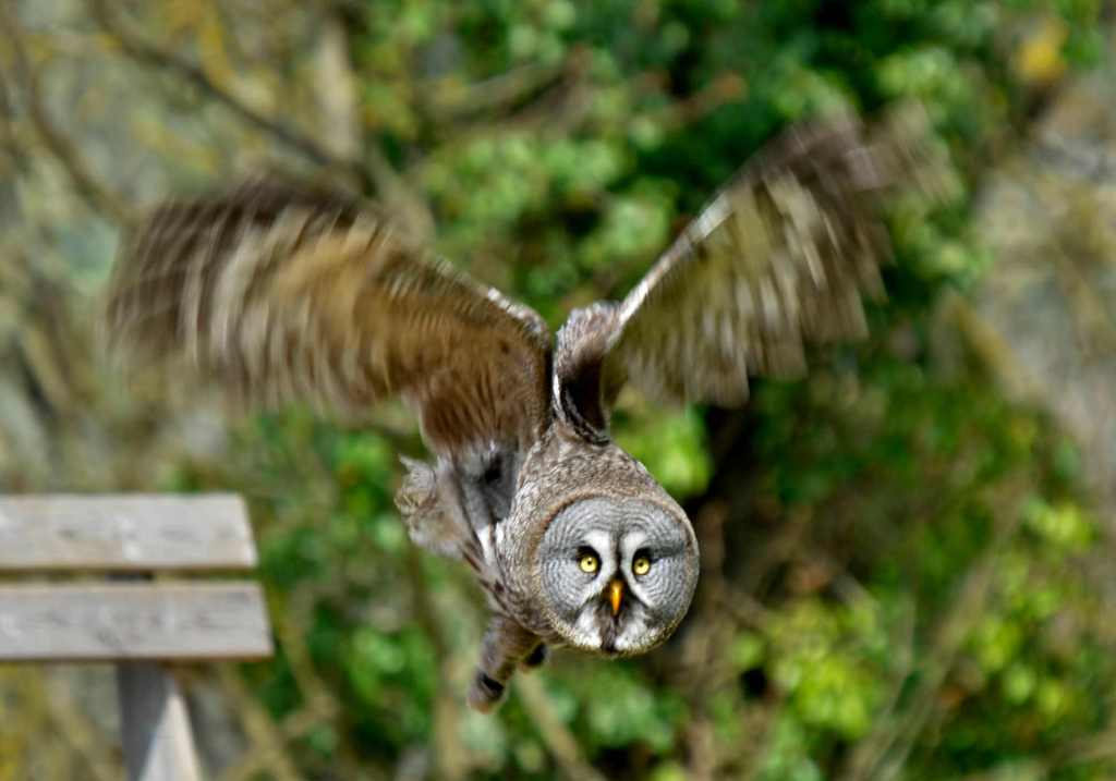
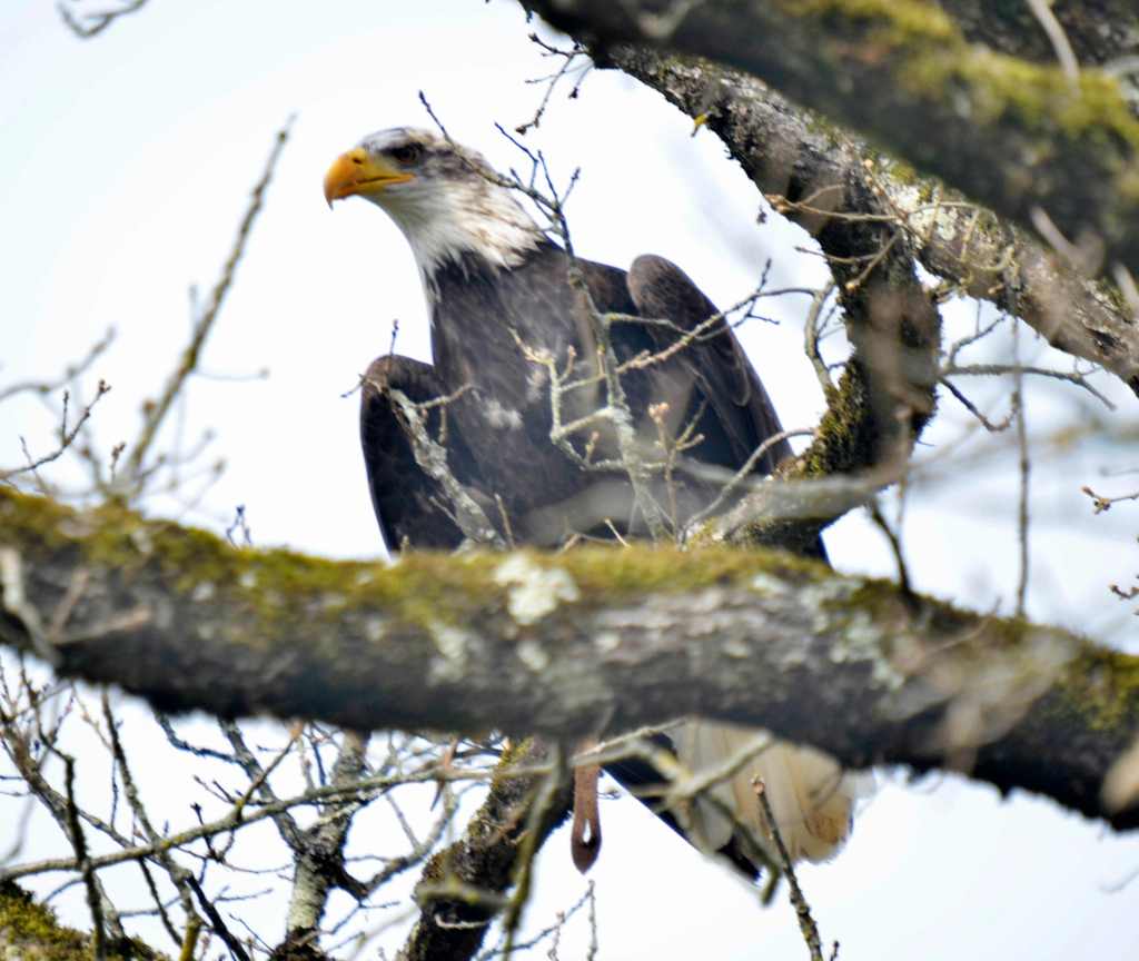
Still, we had returned to the chateau to see the birds and there were some wonderful specimens, including my favourite which was a large beautifully coloured owl. However, the highlight was an eagle but, unfortunately he wouldn’t alight in the area of the show. Though he was a regular, there was something that had him spooked. What could it be I thought?
AT LEAST SOMEONE GOT A PICTURE OF THE EAGLE!
It later transpired that someone from Australia with a tripod and large lens, who wishes to remain nameless, frightened the critter with his mere presence. When I later twigged what had happened (or not as the case may be) it was embarrassing and explained why one French lady gave me a stare portending death as she left the show. Still, since the entire commentary was in French, I felt like I wasn’t really all to blame.
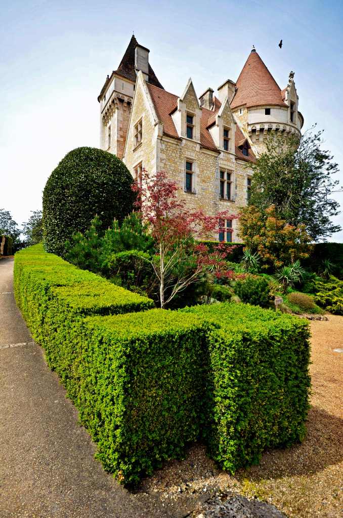
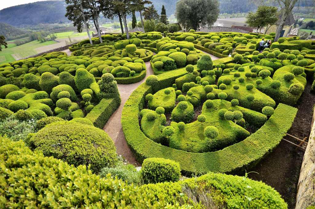
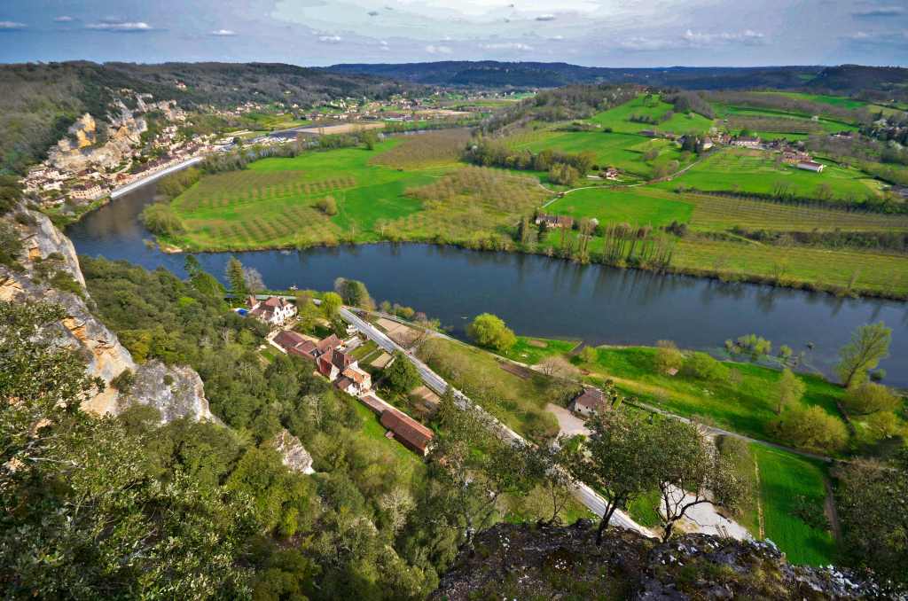
Our next pinnacle of call was the Chateau Marqueyssac, whose gardens of renown, listed as an historic monument, were the main attraction, along with the splendid views from the Belvedere across the valley of the Dordogne from a vantage point of 192 metres. We spent quite a few minutes ogling the verdant countryside just beyond the sparkling waters of the Dordogne.
Set on a long rectangular ridge the topiary has walkways either side and down the middle so you can either view the panoramas or admire the gardens. We did both at this, the most popular garden in Perigord, designed by a student of André Le Notre – famous designer of the gardens of the Chateau de Versailles.
Altogether there are 150,000 hard pruned box trees in the gardens and, no, I didn’t count them to check. After the swirling box patterns there is a long alley of clipped rosemary and santoline (lavender cotton). Altogether there are 6 km of walks divided into three main paths: a cliff path; a high walk and the great walk. All of these lead to a large viewpoint at the end of the garden. The great walk also has a shuttle in high season to transport you to the belvedere if you need it.
We then treated ourselves to a cuppa and ice cream on the balcony of the 17thC chateau and pondered what it must be like to be here in July to the end of August when the gardens of Marqueyssac are open every Thursday evening and lit by candlelight, 2000 of them, and a hundred other light sources, to highlight the beauty of the cliffs and the park. In different areas of the park musicians play. A truly magical evening.
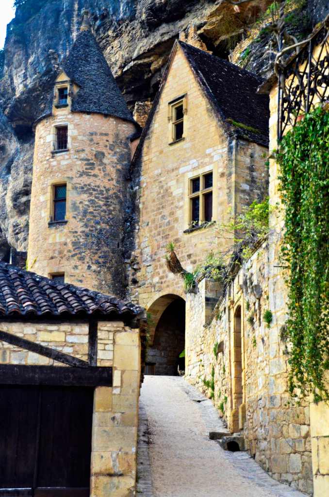
Next we headed down by the riverside to the attractively situated Roc de Gageac whose buildings are seemingly precariously situated against a sheer sandstone rock face that towers way above the village. In fact, some are actually in the rock itself. It’s troglodyte heaven, if you are so inclined.
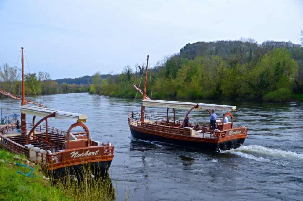
Here we had dinner at a hotel that turned out to be the only downside of the day, re-enforcing my saying that, “eat at a pub, get pub food.” Though not always correct, it so often is. Still, it was nice just being there watching the gabares (river boats with mast near the bow) ply their way along the river with their tourist passengers, somewhat few in number at this time of the year.
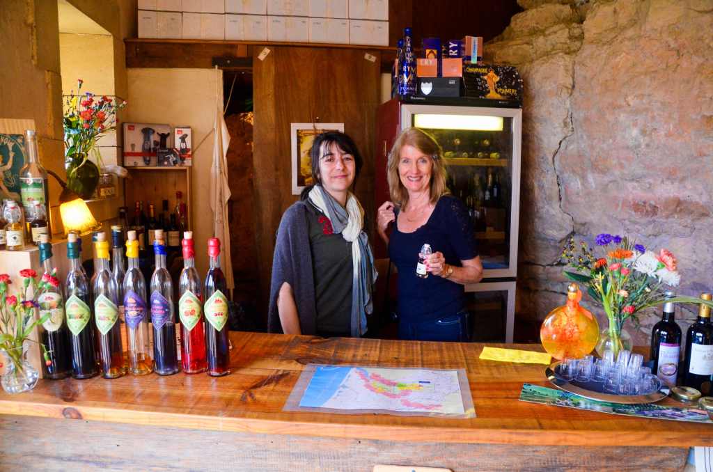
We also climbed up one of the narrow roads and discovered a shop. Inside the shop was liquor (amongst other things) and Lorraine got some free tastings while the absolutely delightful lady who owned the store explained how it had taken her nearly a decade to get the shop up and running.
We had started our day well, going out for an early morning photo session on a crystal clear morning. Walking ancient cobbled stone ways lit by occasional street lights that cast eerie shadows hiding who-knew-what and then finding modern concrete stairways to climb in the soft morning glow of the golden hour, past garden beds whose blooms would come alive in the morning sun.
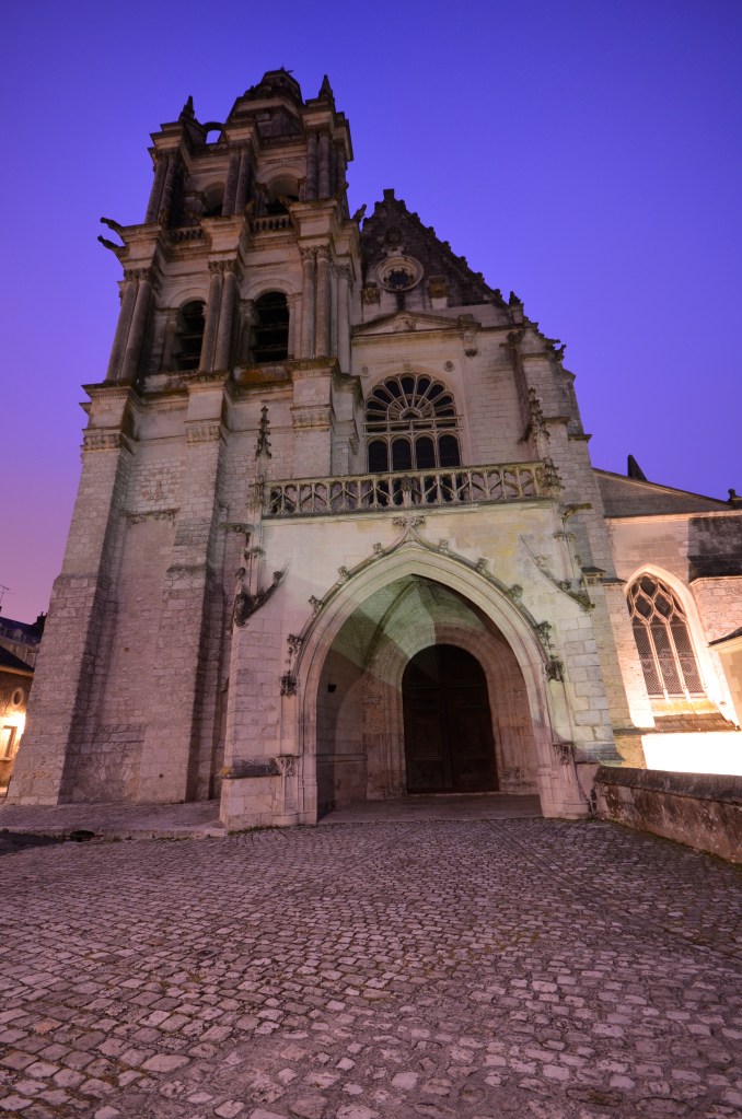
No-one else broke the silence that was ours as we ascended towards the highest church in Blois, the St Louis Cathedral, our footsteps echoing against the stark walls.
The historic architecture is thoughtfully signed with its providence and here and there some type of vine clings to walls with shuttered windows. You hesitate to say “ghostly”, but that’s the feeling you get. We’re out for well over an hour and are totally invigorated by the experience as we reflect over a breakfast that we ravish.
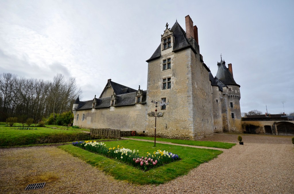
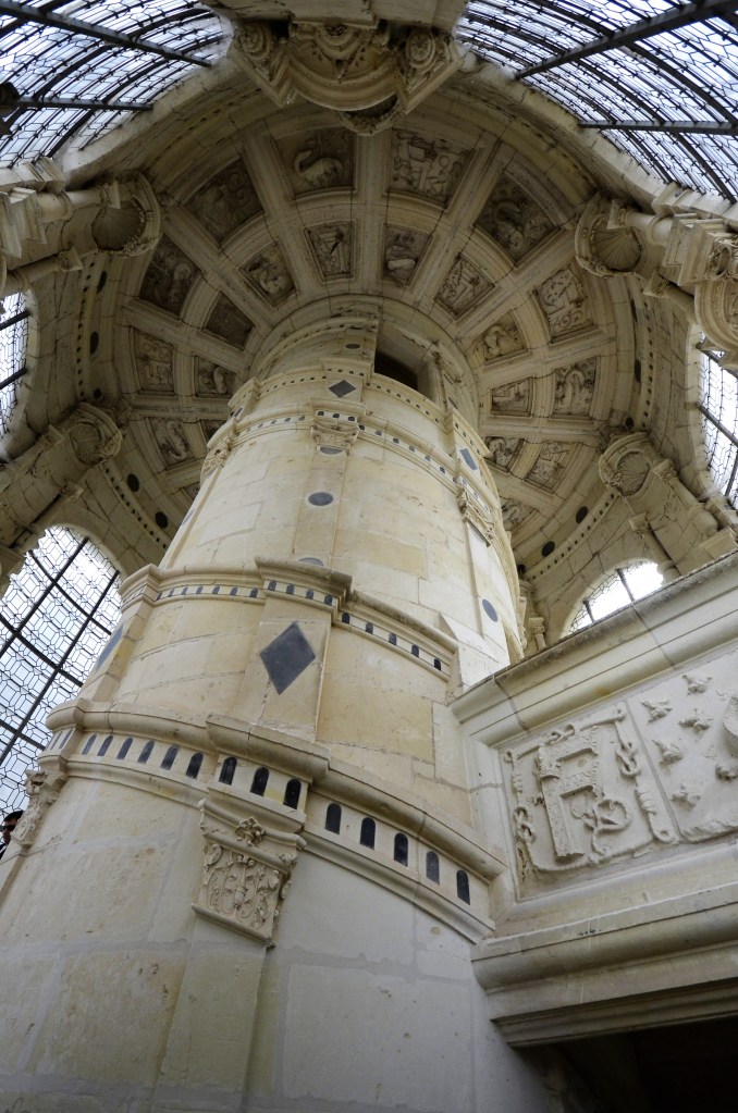
Next we’re heading out to Chambord but then almost immediately going off-plan to view Fougeres-sur-Bievre, a mediaeval castle stuck in the middle of chateau land, aka the Loire Valley. Since we were the only visitors and it was our first such experience on the trip we thoroughly enjoyed it. It was a classical square-shaped affair from the Middle Ages of hard Beauce ragstone with round corbelled towers on each corner with inverted cones on top. Abandoned by the British in 1429 it was totally rebuilt throughout the rest of the century and looked the part.
FOOUGERES-SUR-BIEVRE
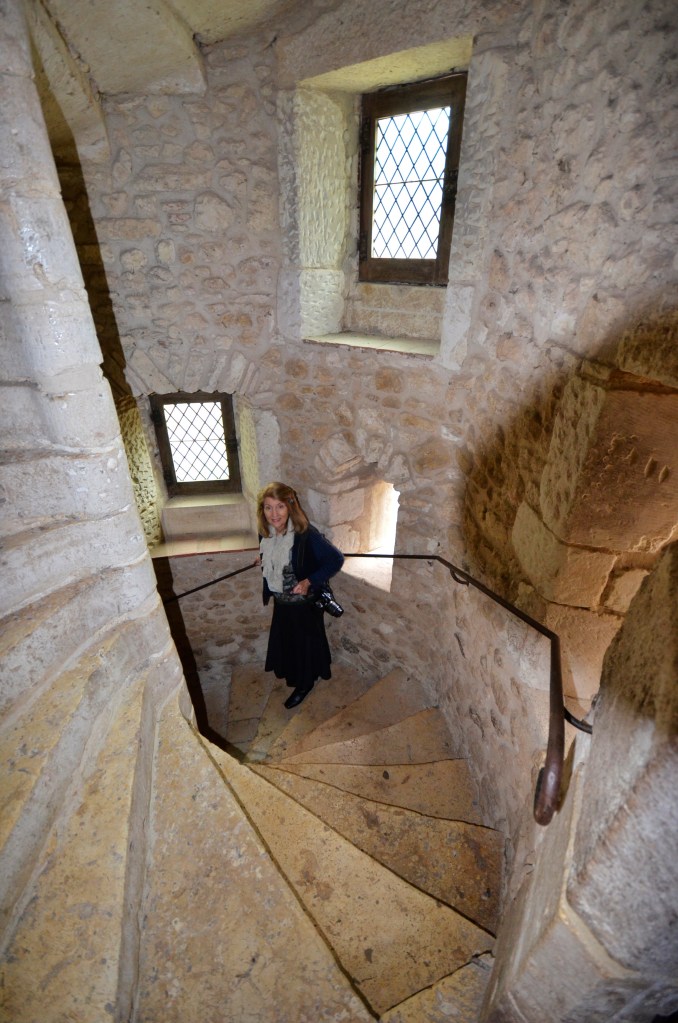
Inside was somewhat sparse so we weren’t detained by furniture but I loved walking up and down the helix staircases and gazing out of the machicolated windows, wondering what barbarians might be seeking to attack us. Outside the building there were a couple of lovely gardens and, somewhat beyond, a tempting chateau apparently not open to the public.
IT’S ALL DOWNHILL FROM HERE
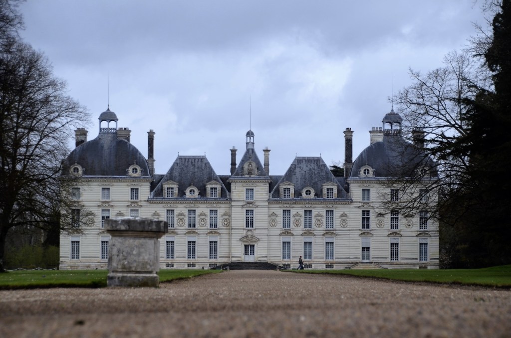
So it was that we left happy and motored on to Cheverny, one of the great chateaux of the Loire; but we had no intention of going in, just stopping for a snap or two, something I accomplished by lying on the ground and shooting between the gap of a gate and the ground.
CHEVERNY
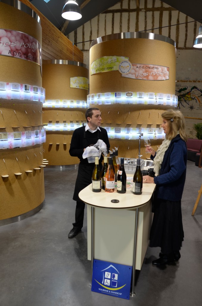
As fate would have it there was a patisserie that we pencilled in after we’d parked and walked past it on our way to the main gate of Cheverny. However, fate took another hand in our schedule yet again as I noticed a degustation area and directed Lorraine into its bowels while I went off to try for a different shot of the chateau.
ONE PERSON’S IDEA OF HEAVEN
How was I to know that she’d walked into wine lover’s heaven, for here, set on 3 cylindrical stands with 32 stainless nozzles apiece, was the piece de resistance of all wine tasting. It truly was amazing because they have set it up so you can get a wine tasting glass for a small fee and it has a computerised chip in it that allows you to taste any three wines of your choice from the selection of 96. However, Lorraine, charming the host, had conned him into some freebies first and then had a go at the glass for nothing. I thought she’d never leave.
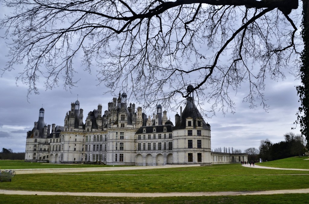
After our patisserie time indulgence we cruised on to Chambord, one of the architectural marvels, not only of the chateau world, but anywhere. Its variance to other chateaux is marked by its extraordinarily complex towers, stairway and adornments. Mind you, the bus tours and hundreds of others had also “found” it the day we were there yet the carpark, about one kilometre from the chateau entrance, was only about a quarter full.
CHAMBORD AND ITS DISTRACTING ROOF TOP
This place can handle a crowd fortunately so you were never stuck behind hordes of tourists like some more well publicized venues. Leonardo da Vinci spent the last three years of his life near here and it is generally believed that he had something to do with some of what we see today, though Italian architect Domenico de Cortona is generally credited with much of the design. In fact, whilst ever you are outside the building, it’s hard to take your eyes off the Italian roof line, so incredible is some of the detail and, at times, it seems almost Gaudi-esque. With 800 columns and 365 chimneys it was definitely the highlight.
Francois I started this off though he only spent 72 nights here but it was much refurbished by Louis XIV before he tired of it and headed off to set up Versailles. It’s incredible to think that it was only ever set up as a hunting lodge!
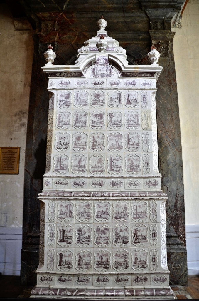
JUST YOUR BASIC HEATING APPLIANCE
Inside we see the first use of coffered vaulted ceilings in France and the huge ceramic heaters that always fascinate me. The three that were here came when the Marechal de Saxe, victor at the Battle of Fontenoy, was installed as manager by a grateful Louis XV. They were all sold off but have since been re-united in their original house. The most mentioned item however, is the double helix staircase that goes for three stories (there’s also another 83 stairways).
It’s extraordinary to reflect that, during WWII, the treasures of Le Louvre were stored here, ever trying to keep them from the hands of the Germans. One one occasion a Lancaster bomber in dire trouble was heading straight for the chateau. Miraculously the wings were tilted and it missed by an estimated metre. Who knows what damage might have occurred. It crashed in the garden just beyond.
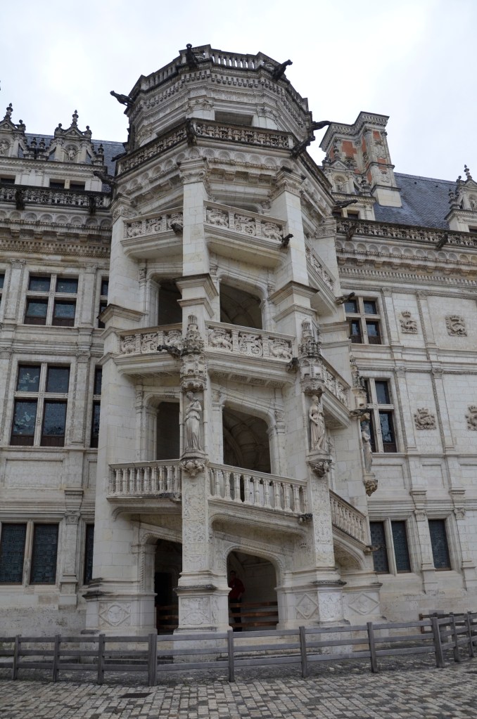
It was a satisfying visit but our next venue was back at Blois, where we’d spent our first two nights. Here was another Francois 1st extravaganza though Louis XII is responsible for much of what we see today of its 564 rooms and 75 staircases, though only one staircase, a double helix, is truly memorable.
Palace Royale’s double helix staircase
The Palace Royale is an impressive building with equally impressive views over the old town and its river. Once a mediaeval fort, it morphed into what we see today via the whims of its many owners, several of them kings, including Louis XII, who was responsible for its conversion into a true palace in 1498. Not long after, Francois I came to power and, inspired by lodges in the Vatican enhanced by Bramante, built the Renaissance wing with its in-your-face staircase.
Though there are only 30 rooms here, one is 540 square metres, while the Kings Room is 173 square metres. Also of passing interest is the fact that there are 6,720 fleur de lis scattered around, 237 candelabras in the Studiolo as well as numerous monograms; Francis I (35), Catherine de Medici (180) and Henry III (192).
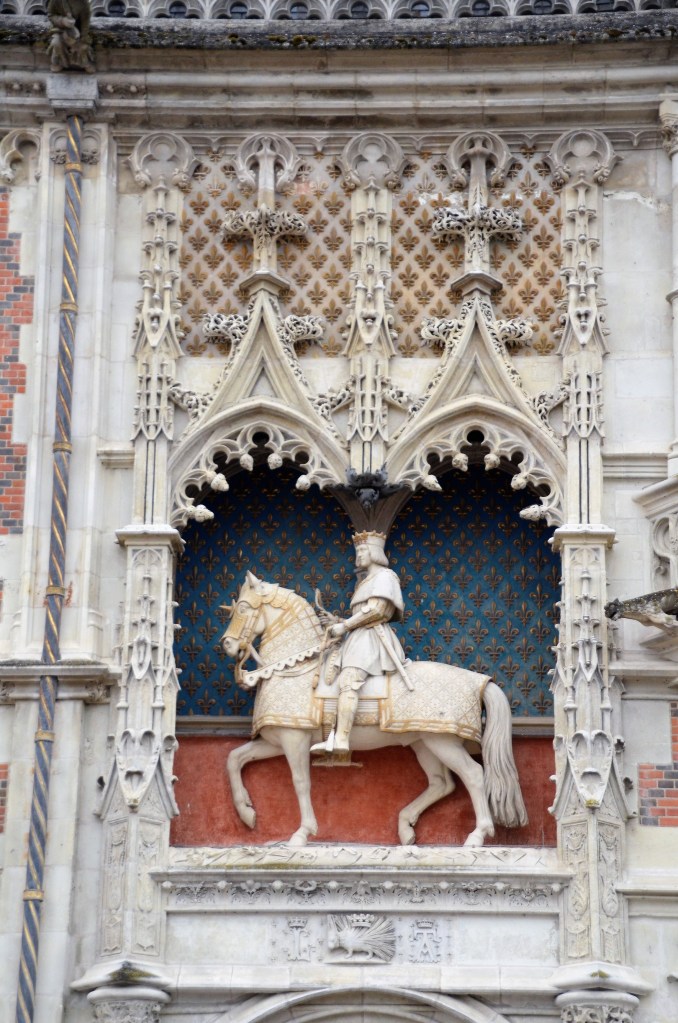
NOTE ORDER OF THE PORCUPINE BENEATH
The only other thing of note during this great day was when, whilst on our way to the Royale, about five carloads of adolescents charged by in their vehicles hanging out of the windows with horns blaring. We were shocked to say the least as they sat on the window sills of the cars and leant out at all angles at speed, seemingly with some sort of death wish.
LA CASTALET, WHAT’S NOT TO LIKE!
We finished up dining at a wonderful restaurant, La Castalet, our second such quality eating experience on our trip thus far, after the Au Buchon Lyonnais, which is one of quite a few restaurants scattered around the country specializing in cuisine from Lyon. This is usually a dish based on fatty meat like sausages, duck pate or roast pork and the conviviality of the staff and owner are also associated with Buchon.
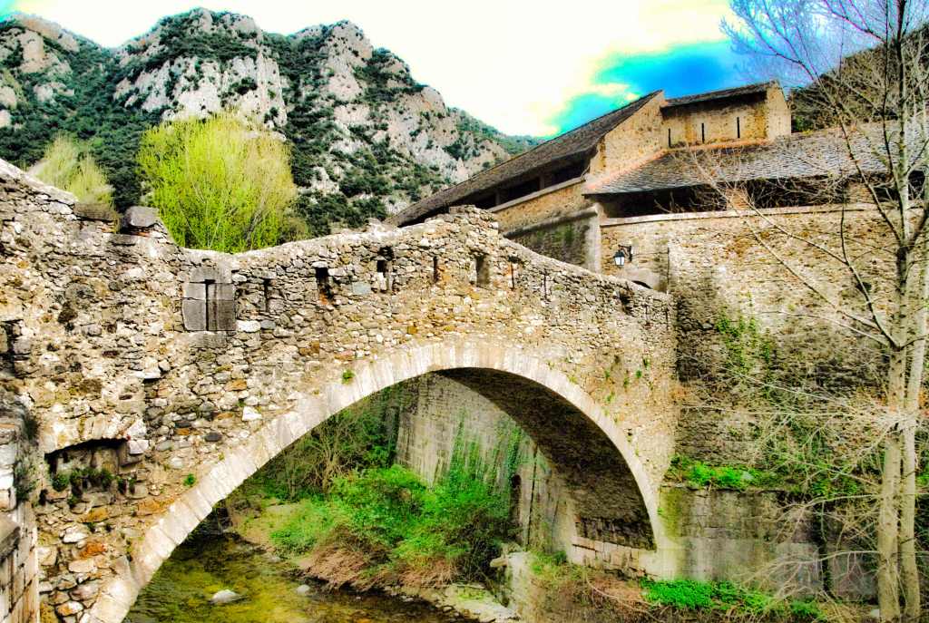
At some point during our 6 ½ hour walk we contemplated such words. We had started out above Le Rozier, the village adjacent to Peyreleau where we were staying. They are separated only by a small stream and a one arch mediaeval stone bridge.
We had climbed for about 20 minutes to get to the base of Capluc, whose name comes from Cap Luuis, the Latin for “peak of light”. In the 19th century they were going to erect a statue of the Virgin Mary up there but apparently the local priest entrusted with the funds, a buxom young lady, and the funds themselves, all disappeared. So, in 1973 they erected a simple cross instead.
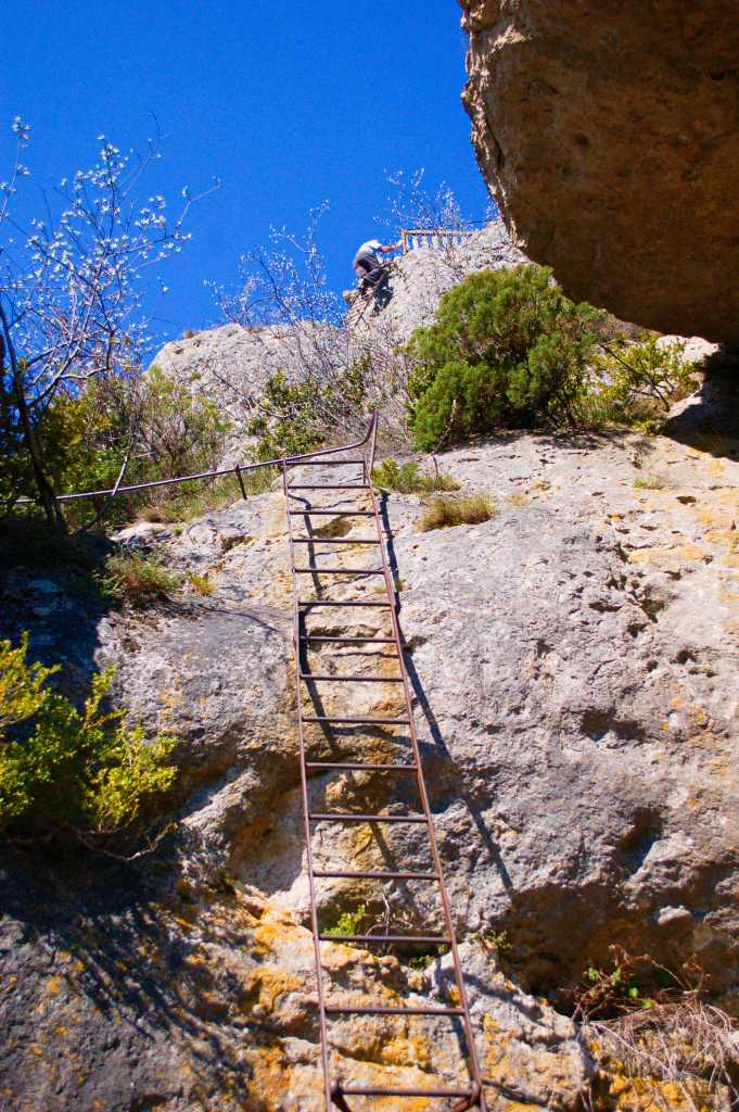
From the base, reached by steep uneven steps, you then have to climb three open ladders (this would not be allowed in Australia!) to reach the very top (Rocher de Capluc) where there’s a small area fenced in.
THE LADDERS ARE NOT RECOMMENDED FOR EVERYONE
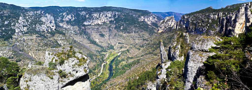
I’ve travelled a bit but can honestly say I’ve never seen a 360 degree view to match it; for below, where the Jonte and Tarn Rivers converge, heading in three different directions are some of the deepest gorges in Europe. Dotted by ancient villages and scarred here and there by the few roads in the area it truly is spectacular.
There’s also the remnants of a stone building here and there beside us, lorded over by domineering rock formations, their roofs long gone, their history unknown, but you know someone could handle the steep incline to one of the better views in France, the abandoned hamlet of Capluc.
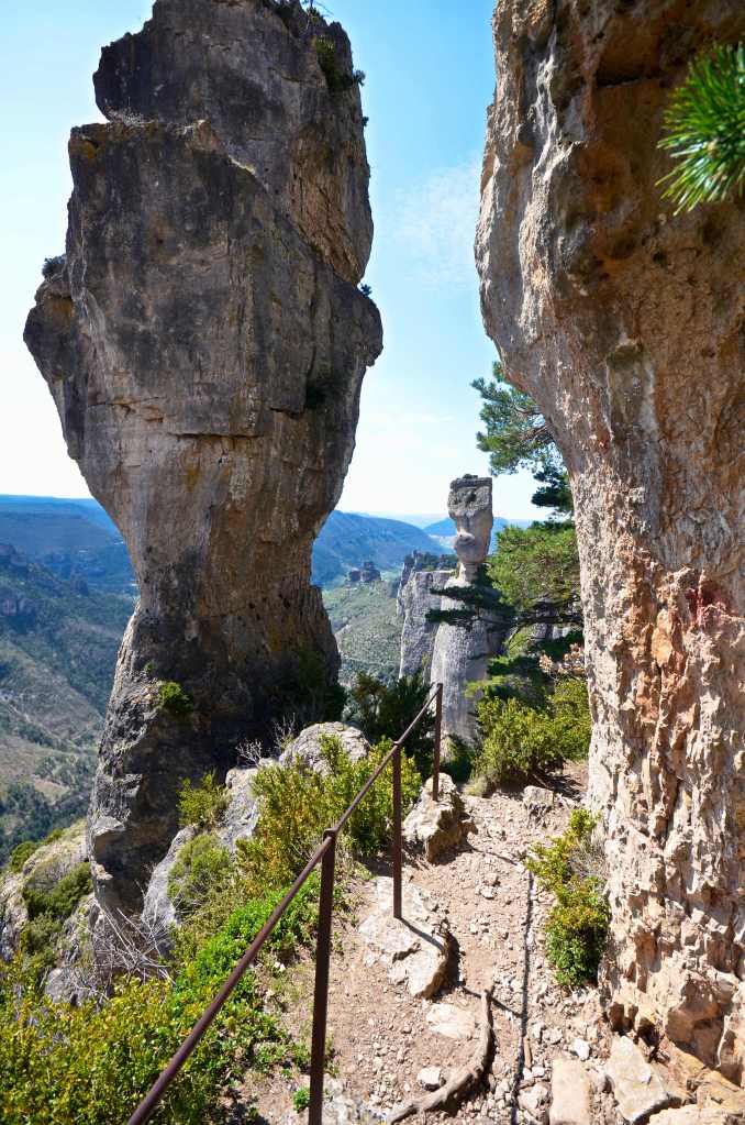
Even more breathtaking are the rock formations, and that was our next goal. For just over an hour we trod an uneven path, ascending through sparse forest to a saddle between two of the giant rock formations. Lorraine was suffering but soldiered on and when we reached the upper part of the walk things were a lot easier across the Causse Mejean.
Every 50 metres beheld new panoramas over sheer drops and beneath were towering ramparts of massive rock walls. It was like our Blue Mountains on steroids only there’s a lot more of it. Occasionally we passed other hikers or they overtook us as we branched out on the loop that would ultimately return us, via even more dramatic formations, something we’d not thought possible a couple of hours before.
VASE DE CHINE AND VASE DE SEVRES
By the time we reached the sheep’s gate, a now disused affair, Lorraine wasn’t really in need of what lay below. For 50 precarious metres beyond the old metal gate, put there to stop sheep from going over the cliff and falling to their death, one had to descend a rock strewn slope with few grips and, it was very steep. Lorraine, somewhat acrophobic, was not amused! However, with some gentle cajoling, some physical help and a reminder that the alternative was over 4 hours to return the way we’d come, she bravely made it to the bottom only to be confronted by other situations along the rim where, without any protection, the abyss awaited you beside the narrow track. I’m certain it was only the thought of a possible long walk back the way we’d come that pushed her onwards.
OVERLOOKING THE TARN
However, the rock formations here were beyond anything we’d ever seen and were right in your face and often towering immediately above you. It was epic, unforgettable and awe inspiring all at the same time. Lammergeyers rose majestically on the uplifting currents and skinks scuttled from the path as we trod onwards. Way below the roads wound like discarded shoelaces beside the river.
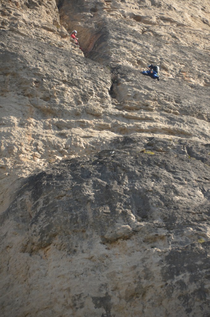
From time to time we came across rock climbers, for here, with over 600 sites to choose from, they have found heaven. Nirvana on a rock face is not something either of us aspire to though we could but gasp at what they were trying to achieve. There were also flowers, odd stuff we’d not seen before.
Reaching the end of the loop and starting down again, our knees weren’t keen at all but, when you do incredible walks like this, somehow the thoughts of achievement blot out the physical hardship and then, there are all those photographs you’ll have to show your friends!
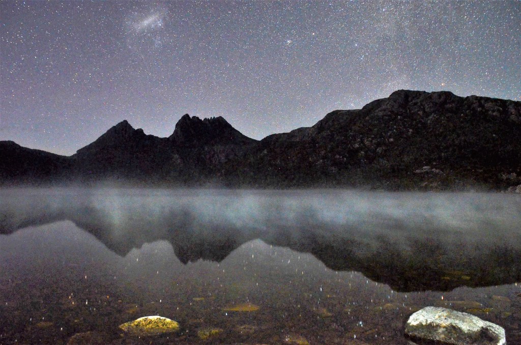
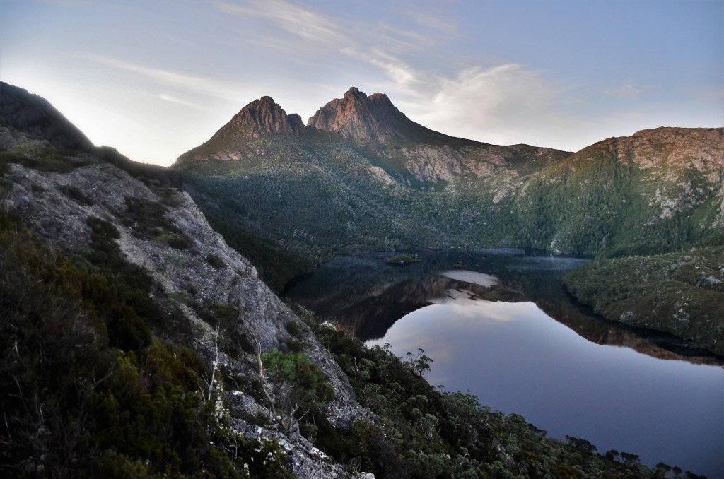
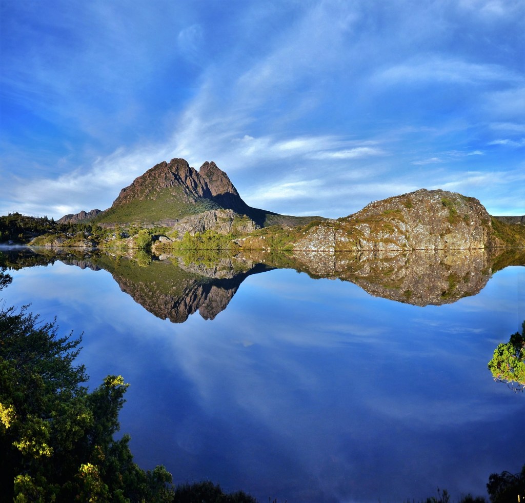
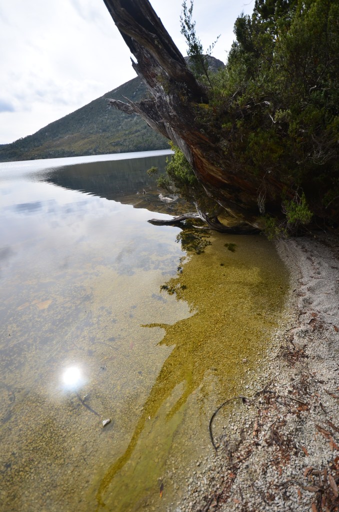
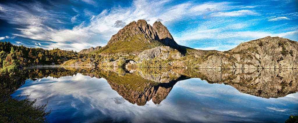
2.30, it’s 2.30, as in a.m. Doubts arise as to the sanity of doing anything at this time of the day; sorry, night, but I’m driven. Once before I’d made the sunrise at Dove Lake, back in the days when you could still drive your motorhome to the water’s edge. These days it’s so popular they have an automated gate that locks when the carpark is full and signs forbidding everything save ordinary cars, but right now I’m a long way from there.
First I have to get ready. Through bleary eyes I start to make my walking breakfast, as distinct from the cereal I’m eating now. My head wants to be on a pillow but the driving factor of the possibility of seeing stars over Dove Lake is irrepressible. I’d been thinking about it for months.
EARLY MORNING DOVE LAKE
It’s raining outside, another reason I shouldn’t be going. The weather forecast has consistently said, “slightly cloudy”, maybe Cradle Mountain will be different.
I’ve already packed my camera gear when I finish with eating I get appropriately dressed, leave some food for the surprised animals and I’m on my way except, 8 kms down the road, the thought that my wallet isn’t on board registers and I turn back. If it was only for my licence I wouldn’t have bothered, but I know they’ll be looking for my national parks pass and I’ll be starving later thus money will be required.
Refocused I recommence my journey and the one thing I constantly worried about takes about 20 minutes to eventuate – potoroos! Whatever road you travel on up here you’ll see many that have successfully achieved their suicide mission.
They’re everywhere, it’s like driving through a never ending chicane, whether they’re alive or dead. You can’t do more than 70 with any measure of safety so it adds over half an hour to the trip. I’ve taken the slightly longer route in error as well, meaning there’s more corners and more possibilities of hitting animals. With every passing kilometre the slip-slap of the wipers is incessant, making me wonder about the wisdom of the venture even more.
MAGIC MORNING AT DOVE LAKE
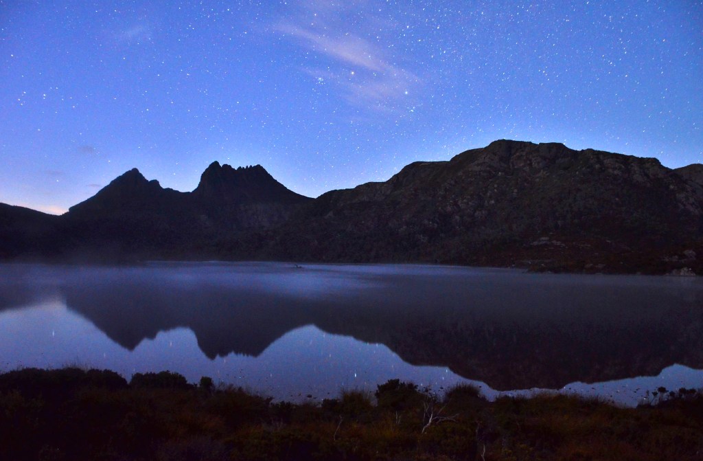
There’s nothing on the road except animals and it keeps you alert and takes my mind off the improbability that I’ll be successful. The final road in is Belvoir Road and, about 20 kms shy of the national park, the rain finally stops. At least I’ll be able to get a shot perhaps I’m thinking. Then, through a narrow gap in the clouds, a crescent moon briefly puts in an appearance. A shining light of hope perhaps?
I turn onto the final entry to the national park and head down the last 8 kms, past two eastern quolls and a possum; there’s no more rain and occasional breaks in the sky; by the time I reach the shore of Dove Lake, it’s like a miracle has occurred; there’s not a cloud in the sky.
Just how shy of dawn it was I had no real idea, I just rushed to get my camera gear ready, fumbling here and there in an effort to get everything together, making sure I had some food and not forgetting the drink, as I had done on the Mount Murchison hike.
At this time of day, in this kind of place, it’s eerie. Your ears are straining for sounds that never come, your eyes seeking somewhere to place your feet safely on the ground, your olfactory senses picking up some scent or other from the native bush; everything is heightened. It’s not until I reach the shore when the soft sound of tiny ripples stirs my eardrums that I can relax a little.
I’d hoped for millpond conditions so I could get the stars reflecting in the surface but there’s a surreal mist clinging to the surface of the lake, its ephemeral nature will become apparent when the sun bursts through. Meanwhile, I’m stretching out my tripod, getting the settings right on my camera (not as easy as it sounds) and praying conditions stay the same. The shots start clicking off, 30 second exposures of the Magellenic Clouds hovering over Cradle Mountain and then the artistic side of my brain starts running amok. “Where can you get a better angle?” it keeps harping; so I find myself moving hither and thither around the northern end of the lake, at times stepping in the muddy foreshore. I play the light of my head torch onto the foreground to try and add some depth, maybe pick out the fog or highlight some reeds. It’s like working to a deadline governed by the sun.
Mercifully I’ve arrived early enough so that I can make some mistakes but hopefully ensure that there’s some good shots in amongst them. Then I get a fetish to go and shoot the famous boatshed; it’s a sort of “have to do it while you’re here” thing but halfway there realize it’s taking up valuable time and it gets overridden so I do a U-turn and I start my big hike, initially on the eastern side of Dove Lake until I reach the Y intersection where Lorraine and I had gotten “misplaced” previously and turn left onto the Lake Rodway Track, starting the climb to Mount Hanson.
THE CLIMB TO HANSON OVERLOOKS DOVE LAKE
First light is appearing in the sky as the stars are banished for another day and there’s the tiniest wisp of cirrus forming up over Cradle. I reach the point where Lorraine and I had lunch only a few days earlier and have to make a decision; continue on Rodway or drop onto the category 4 Lake Hanson Trail. Though I know the former will get me to Twisted Lakes sooner, I’m torn by the fact that maybe there’ll be a photo opportunity at Lake Hanson and knowing there are chain sections on Mount Hanson so I head down and soon after discover why it’s rated a 4. It’s rugged and bum slides have to be undertaken here and there just to get down. It’s certainly not a place for the average stroller.
THERE’S NO EASY GOING ON THIS TRAIL
Constantly on the lookout for angles and interesting bits of nature, it’s not very fruitful until I come to a part of the trail that is tree roots and nothing else for about 40 metres before reaching a couple of ponds just above the lake itself. Here, the still waters and skeletons of trees long since dead lend an artistic atmosphere to the journey and I add some time to get a dozen snaps.
LAKE HANSON DAWN
After this it’s still rugged but uphill, testing your strength and skill at times as you wonder just when it’s all going to end. It’s supposed to be an hour loop but I’m sure I’ve taken that already. Then the top of Little Horn peeps up on the horizon, maybe I’m getting close I think. Within another 20 metres the whole purpose of the excursion becomes apparent. The vista before me is simply breathtaking. Twisted Lakes is but a mirror, everything I’d hoped and planned for has come to fruition.
THE MAGIC OF TWISTED LAKES
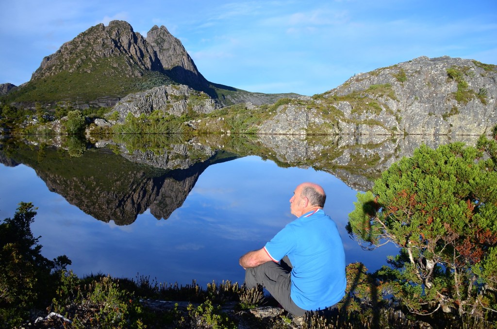
When you come upon something as good as this, it’s overwhelming. The sheer majesty of the panorama engulfs you, its power makes you feel so humble in its presence, there’s a distinct aura of “something else”, but it’s indefinable. It’s all my grey matter can do to remind me that I’m here to actually take photos. You just don’t want to stop looking for fear that it will all go away and you’ll be denied any more pleasure; but it stays as I set up the tripod. It’s not often I put myself in the picture, but here I feel it’s a must. Then I can look at it and remember just where I sat and how good it was.
A SPECIAL PLACE, A SPECIAL DAY
There are many angles to be had here. Faint trails indicate where other photographers have been, little flattened sections indicative of footfalls. It takes me around 15 minutes to get what I came for and then I sit down and enjoy breakfast, although “enjoy” seems like a totally inadequate verb in this case, there is a higher plane involved here, one you get to experience so few times in life.
The cloud, mainly cirrus, has started to form more seriously now, as predicted, and it adds a little to the experience. Changing lens and shifting position constantly I can but hope I’ve got it covered and, even as I’m moving around, the first gentle ripples of the day’s breezes disturb the surface. Had I been here any later I would have missed it. You like to think it’s good fortune but reflect on that fact that you’ve planned it for a week, constantly following the weather patterns, in the hope that you’ll get it right and leaving early enough to avoid all the problems that occur later.
FROM IN FRONT OF THE HUT
The time has come to move on. From here I pick up the Rodway Track again and come across a hut. About 50 metres in front of the hut is yet another reflective pond so I do a diversion into there before heading out again and soon I turn off onto the Face Track. I anticipate this will be a straight traverse across beneath the Little Horn and then down to Lake Wilks. Oh dear, did I get that wrong.
THERE’S A GAP IN THE ROCK BAND JUST LEFT OF CENTRE. THAT’S WHAT YOU HAD TO CLIMB THROUGH
It climbs and then climbs some more. My tired legs are in fear that I’ll have to scale the rock band at the base of the mountains and with good reason. Though I check my map twice there’s no way I could have taken a wrong turn. The massive buttress is before me and there’s a small cleft where the trail goes. My whole body now is rebelling but I have to go there, hand over hand hauling myself up the rock face until, finally, the track turns to the right and levels out.
AS MANY PICS OF ME IN THIS POST AS ANY TEN OTHERS
I stumble gratefully along until the intersection with the Lake Wilks Track is reached. From here it’s downhill all the way, only it’s another grade 4 route so I anticipate more suffering and am not disappointed. It’s rugged, rough and, at times, dangerous. I’m grateful I’m an experienced bushwalker and can negotiate such ways but I’ve exerted more energy than I anticipated and I pause here and there for a drink and to recuperate.
YOU COULD WALK IT, BUT THE CHAIN IS MUCH APPRECIATED
Then comes the chain section, about 100 metres of it, in order to negotiate what must have been a pretty scary section before they put it in. As I start the serious descent I can hear voices, the first human sounds since yesterday. I’m about ¾ of the way down the chain when we meet and greet each other. They’re from England and have done extensive walking over there. They marvel at how you can come to a place like this and have it almost to yourself, cross referencing it with the Lakes District where there are crowds wherever you go.
LOOKING DOWN ON LAKE WILKS (LEFT) AND DOVE LAKE
We continue our separate ways and Lake Wilks seems to take forever to arrive as the track goes one way and then another. Eventually I reach it and am surprised at the photo opportunity it offers.
LAKE WILKS
I guess the reason it hasn’t been covered more extensively by photographers is that it’s always on the way to somewhere else, not a destination in itself. I probe into a couple of spots and then move on. A pair of tattooed hikers go past as I’m shooting the small stream that flows from the lake. No greetings are exchanged as they seem to be on a mission so I pack up and move further down towards Dove Lake.
It seems an eternity before I finally reach the most popular of tracks and slump down and have a drink at the first available opportunity. The car is still an hour away but at least I’m on grade 2 now and can move along at a reasonable pace and there will be conversations to be had.
As I come across “normal” tourists I’m told “It’s not far to go now”, they assuming I’m some old fart struggling to do the normal flat track around Dove Lake. I must look bushwhacked to them and, since I have boasting rights, I explain I’ve been walking for six hours and not just the two hours around the lake as they might be expecting. When I point out where I’ve been on high, some sympathy is clearly discernible.
The small climbs up easy steps take on a new dimension. I want a chopper to come over and airlift me out or to be chaired out on a litter. Each passing step comes at a cost and my 70 years on the planet are making it known. Each rest point is utilized as I slowly make my way back to the car. Someone else who’s done the same walk recorded over 10,000 steps and they ultimately come at a price but, when the carpark is finally reached, I’m so glad I came today and did what I did. Somewhere deep inside a contentment reigns supreme. Surely there’ll be a photograph in the camera somewhere that will justify the trip.
Next morning, after having gone to bed before 8 p.m., we’re awake around 5 a.m. and I’m restless to do some writing. Despite creeping stealthily down the hallway and through the door into the dining room, where our computers are resting, I make one small noise and it seems that almost instantly Sheila’s face pokes around the doorway and queries as to my well being. “No, everything’s fine”, I assure her, feeling guilty about having woken her, but it seems hardly any time at all before Lorraine’s in the room as well and Sheila has a cup of tea made.
We’re delving into yesterday’s photo production and the results are pleasing, leaving us with pictorial memories that will bring pleasure for years, but we still find it hard to come to terms with the fact that when 7 a.m. rolls around there’s still no evidence that the sun might return for another day.
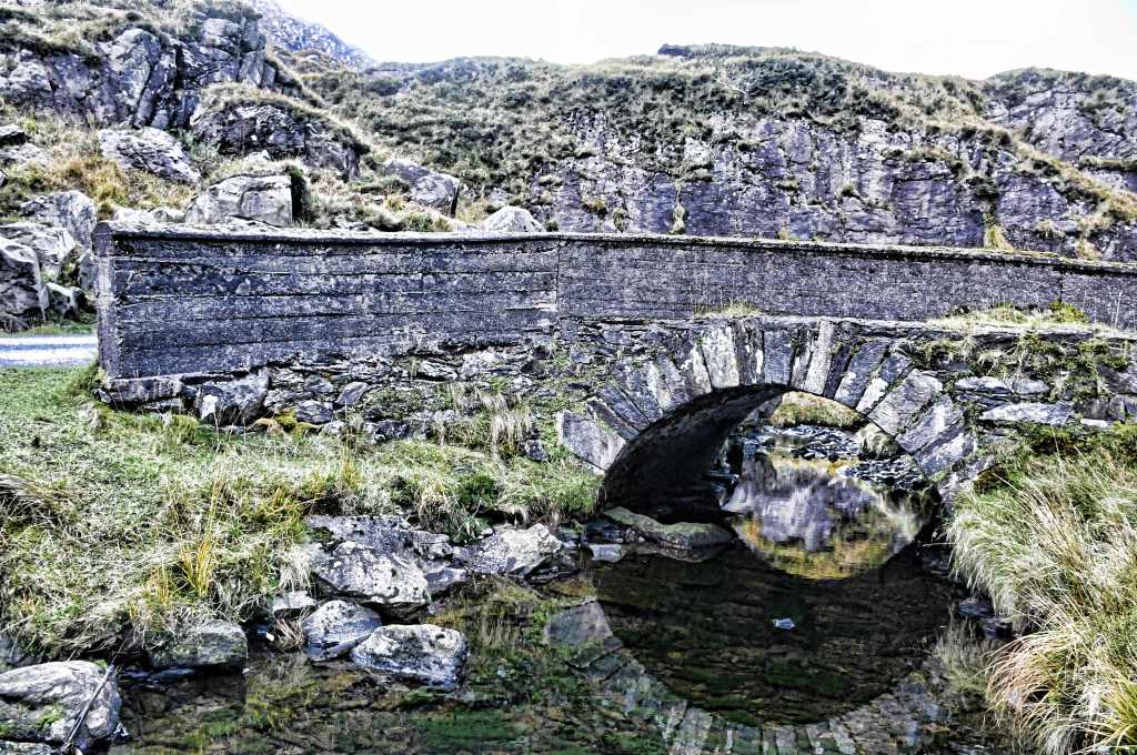
EARLY MORNING AT THE GAP OF DUNLOE
Still, after breakfast, while Lorraine’s packing her suitcase, I escape outside and, for the first time, pull my birding lens out of its bag and record some of the avian species that abound around the farmyards. No sooner do I start than I regret not having done it sooner and, not long after that, I’m summoned back inside to finish my packing so we can be gone.
The Skoda fires up and we bid Sheila farewell, wondering just how much longer she can keep running this rustic place, such a treasure for nature lovers though not for Lorraine who down marked it severely for the overcooked dinner we were served the first night, the smallness of the rooms and bed and the tiny bathroom area with a toilet that croaked for several minutes after you used it whereas I was bug-eyed just looking at the panoramic view out the window and the sheep wandering right by; everything else didn’t matter much.
FAR SIDE OF THE GAP OF DUNLOE
We climb over the Gap for the last time and, despite Lorraine’s focus on moving on, I insist on taking a last picture or two because there’s fog in the valley floor and it looks magic as the sun caresses the top of the mist and highlights the colours of the slopes. Over the crest and down the other side there’s no direct light at all and I manage to stop a couple of times more. Lorraine actually gets out at one and takes her best picture of the trip so far, one of a stone bridge and the water beneath that you can see through all the way to the bottom where the green growth is so clear you’d almost swear the water wasn’t there.
STONE BRIDGE ON THE GAP OF DUNLOE
Further down I get a shot of a derelict building that I’d missed the day before and find much satisfaction in the result but, we’re on our way to Adare, a town of promise and the prospect of a castle visit. Lorraine’s so excited she falls asleep for half an hour and wakes just in time to enjoy the arrival into this chocolate box top place where almost every building is a picture in itself.
We call at the local tourist office and the abrupt girl manning it tells us brusquely that the castle isn’t open because it’s off season. I’m in shock. Initially because it is closed and secondly because when we’d visited Muckross Castle the day before there were hundreds of tourists. However, she doesn’t care and immediately jumps back on her computer, obviously annoyed at the intrusion on her life while we are left standing wondering what to do next.
She had given us instructions on how to view the attraction from the road so we followed those which took us past so many thatched roofs we were entranced. Built by Lord Dunraven in the 1820s they are a noted tourist attraction these days though three were, sadly, burnt in 2015.
ANOTHER CHOCOLATE BOX TOP
The town only became an earldom in 1822 and, when the 7th Earl died in 2011, the title went with him. The Dunravens were responsible for much of the eye-catching architecture and town layout you see today.
In 1756 John Wesley preached to the people of Adare from under an ash tree near the Franciscan Friary but the tree died around 1860. Today a stone marks the site where this tree stood and the Methodists hold a Field Meeting here in June each year.
Further down the road we chanced upon a local school that was built upon the remains of a 14th century Augustinian Abbey, colloquially known as the “Black Abbey” because the monks wore black habits. The school itself celebrated its 200th anniversary in 2014.
We chanced our arm and walked in and managed to see some interesting stuff like the cloister and some in-memoriam tablets from the 19th century but couldn’t go further because the rest was taken up by the school.
WATCH FOR TRAFFIC!
Then we crossed the bridge over the river Maigue, somewhat tentatively I should add as there is no walkway, just two traffic lanes and when trucks come past on this busy highway it tends to be unnerving. Here is the best view of Desmond Castle, a 12th century structure trashed by Cromwell on his destructive visit to Ireland around 1657. Elsewhere in the vast grounds there is an impressive manor house, one of those “if you have to ask the price you can’t afford it” types. Apparently the interior is stunning if a little dated in a couple of areas.
We turned around and headed back to the village and the Dunraven thatched cottages that give the village such a magnetic attraction. En route we pause for five minutes in the local park with its avenue of mature trees and streamlet running by. Is there nothing in this place that isn’t beautiful?
SIMPLY GORGEOUS
There’s barely time for a cuppa, watching eye-popping farm machinery go by that would require an escort in Australia and admiring the delightful colours of the business facades. Such a change from modern boring shopping centres back home.
Oh sweet Adare, Oh lovely vale Oh soft retreat of sylvan splendour Nor summer sun nor morning gale E’er hailed a scene more softly tender Gerald Griffin 1803-1840
THE TRINITARIAN PRIORY, THE ONLY TRINITY ABBEY IN ALL IRELAND
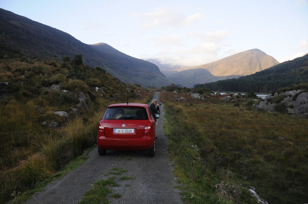
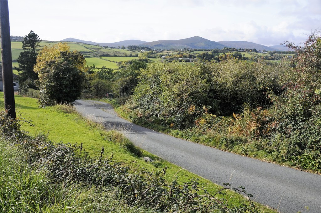
Powerscourt, I’d never heard of the name and only came across it by chance when I was researching a route to take from Dublin to Waterford. Now, if you simply hit the motorway you can be in Waterford in under 2 hours. The way I chose was more like 4 hours. As we travellers are wont to say, “Getting there is half the fun”. Still, I had to weigh up Lorraine’s stamina because I already knew that Powerscourt would involve walking.
I was shattered when I discovered that the gardens are rated at number 3 in the top ten in the world, according to no less an authority than National Geographic. It was time to rectify my ignorance and go for a visit.
We thought we’d had trouble the day before without using a true GPS; today was just as bad. I’d written down the route we wanted to take and handed it to Lorraine. Unfortunately, just as we got on the M50 out of town, she realized she’d lost the bit of paper. I further compounded the error by believing that I’d memorized enough to take us straight there. It was only half an hour away, how hard could it be?
By the time Lorraine had worked out where we were, I’d actually overshot all the turn offs, despite seeing a brown sign with the name Powerscourt written on it too late. The trouble is, in many places, vegetation has obscured some of the signs and I’m still waiting for the arrow. Now, with panic rapidly rising in the seat beside me, I take the next available turn off, spy a photogenic church and pull up to take a picture. Panic in the seat beside now escalates but I’m determined and go and grab a few shots before we’re on our way, this time with clearer instructions now that we’ve worked out “Here We Go”, the app we’re using.
It’s not that far away but we first come to a real charmer in a village called Enniskerry. It’s straight out of the “cute” manual and we decide that’s where we’ll have lunch after our visit. Powerscourt is just up the road and you travel through what can only be described as “gorgeous” countryside to get there. Travelling through the 250 year old beech trees lining the road is an absolute delight. It’s a huge estate, with two golf courses as well as accommodation in a mansion before you reach the carpark where we can immediately ascertain that we’re not the first to arrive.
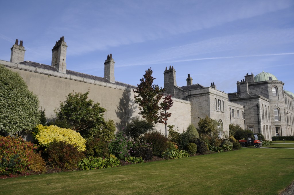
Some places have a wonderful feel about them, this is one. In 1730, wishing to flaunt his wealth, as they did, the Earl of Powerscourt commissioned a German born architect to turn his then castle into a mansion. How ironic that the architect’s surname was “Castle”!
The gardens, so evocatively portrayed in many a picture, don’t disappoint. In 1844, at the age of 8, Mervyn Wingfield, 7th Viscount of Powerscourt, inherited the title and the Powerscourt Estate, which comprised 200 km² (49,000 acres) of land in Ireland. When young Lord Powerscourt reached the age of 21, he embarked on an extensive renovation of the house and created the new gardens.
Even the story of the terraced Italianate section is worthy of inclusion. Apparently, the architect of them, Daniel Robertson, would hide in the dome at the top of the house when the sheriff’s officers came to arrest him because he was constantly in debt. Not only that but he suffered from gout and directed operations from a wheelbarrow, fortified by a bottle of sherry. When the sherry ran out, work stopped for the day.
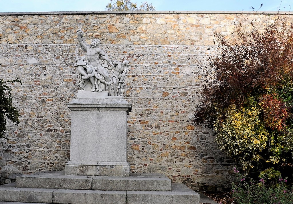
That it took 12 years and 100 labourers to complete the task is no surprise, but that’s only a part. We skirt along the top of them towards the walled garden and pass the largest of the sculptures, that of Laocoon and his sons being strangled to death by serpents. Laocoon was a priest of Apollo in the city of Troy and he tried to warn the inhabitants not to take the wooden horse. However, Athena and Poseidon were favouring Greece and so sent the sea serpents to kill Laocoon, the act shown in the sculpture. The original, described by Pliny the Elder as a masterpiece from the sculptors of Rhodes, was unearthed in 1506 and immediately purchased by Pope Julius II and became the feature in the Vatican’s sculpture garden. I’d come across a replica in the Knights Palace at Rhodes many years ago and was so impressed I’ve never forgotten it.
THE ALMOST HIDDEN LAOCOON STATUE
Aeneas was one person who did heed Laocoon’s warning and he fled, later to found the city of Rome, from where the original work was purchased. The single piece of granite on which the Powerscourt copy stands took two weeks to move on rollers from Glencree, all the while supervised by Robertson who sat on top of it!
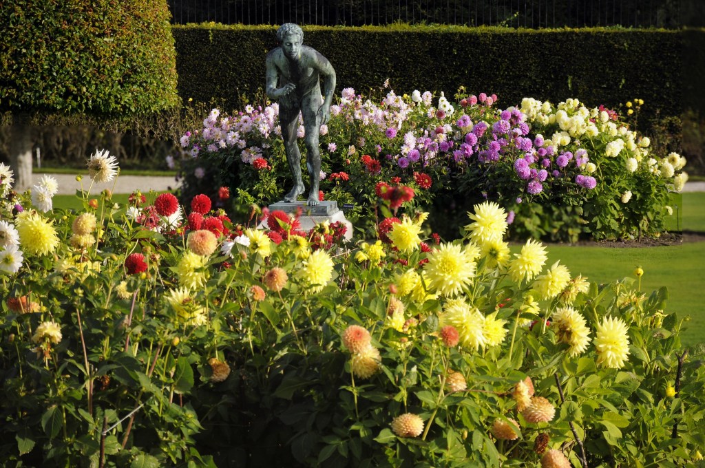
Inside the Walled Garden are some copies of famous bronze statues of ball throwers found at Herculaneum (one of the other places buried along with Pompeii). As we stroll through it’s obvious that spring and summer would be the preferred time to view these areas and we move down into the woods and past the pet cemetery that contains about 50 deceased animals of various kinds.
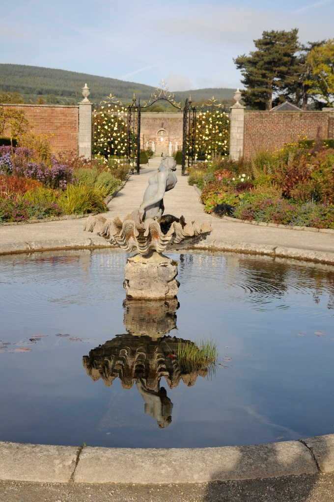
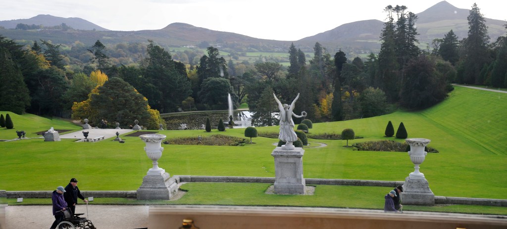
Immediately after you come to the picture postcard view of the estate beside Triton Lake. Looking across you see the life-sized winged horses done in zinc, as represented in the family coat of arms while in the middle of the lake is a fountain modelled on that of the Piazza Barberini in Rome. Beyond is the cascading water that emanates 25 metres from the back of the house and tumbles down the entire slope to the pond.
We move on to the Japanese Garden, the one that Lorraine has been enthused about from the moment she first knew they had one. At last she finds comfort in this exceptionally landscaped section, at this time of the year one of the crowning jewels. Its nooks and crannies are as intriguing as they are delightful and the autumn hues splashed seemingly at random offer colour for the soul to savour.
INSIDE THE JAPANESE GARDEN
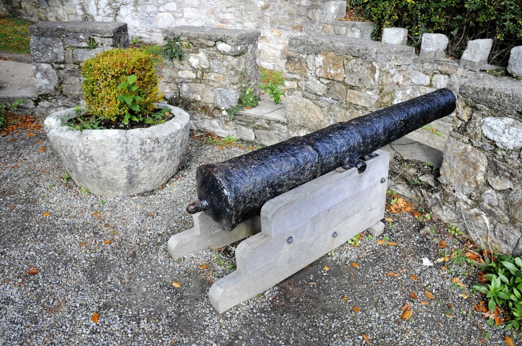
Next we climb further through the 1,000 acres to the famous tower, modelled on, wait for it, a pepper pot from the dining table; hence its name “Pepperpot Tower”. Lord Powerscourt was an avid fan of the scouting movement and used to survey the area from atop when the scouts had camps there. There are cannons as well, some from the Spanish Armada and the Battle of the Boyne.
Then we curve back to the mansion, past the ivy covered tea rooms, so tempting but we’ve already decided on Enniskerry. The Slazenger family bought the place in 1961 and fitted it out as a tourist destination that was opened in 1974. Tragically, on November 3rd a fire gutted the main rooms, leaving them a roofless shell. It wasn’t until 1997 that it was finally re-opened. We troll the shops inside the mansion; so tasteful but with a price tag to match; i.e. if you have to ask, you can’t afford it, but hunger overrides all other interests and we depart for Enniskerry.
FINERY FOR SALE AT THE SHOPS
It’s a popular little place, no doubt bursting at the seams at peak times and we settle into a nice restaurant with art-adorned wall and gaze out onto the streets that have been used many times as a backdrop for film and T.V.